Bloomsbury
| Dzielnica Londynu | |
 Bloomsbury | |
| Państwo | |
|---|---|
| Kraj | |
| Region | |
| Miasto | |
| Gmina | |
Plan | |
Położenie na mapie Wielkiego Londynu Contains Ordnance Survey data © Crown copyright and database right, CC BY-SA 3.0 | |
Położenie na mapie Wielkiej Brytanii (c) Karte: NordNordWest, Lizenz: Creative Commons by-sa-3.0 de | |
| 51°31′12,360″N 0°07′43,679″W/51,520100 -0,128800 | |
| Portal | |
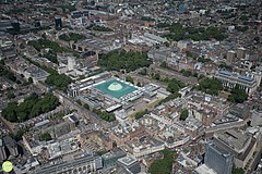
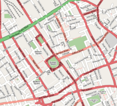
Bloomsbury – dzielnica centralnego Londynu w położona w gminie London Borough of Camden. Charakterystycznymi punktami dzielnicy są liczne instytucje naukowe (np. siedziba University of London) oraz Muzeum Brytyjskie. Niegdyś znajdowała się tam Brytyjska Biblioteka Narodowa (the British Library).
Dawniej był tutaj największy targ owocowo-warzywny w Londynie. Jeden z angielskich country-dances z XVIII wieku (1703 r.) nosi tytuł Bloomsbury Market.
Nazwa dzielnicy użyta została przez grupę angielskich intelektualistów, którzy utworzyli tzw. Grupę Bloomsbury (ang. Bloomsbury Group); również jako nazwa wydawnictwa znanego z wydania serii o Harrym Potterze.
Media użyte na tej stronie
Contains Ordnance Survey data © Crown copyright and database right, CC BY-SA 3.0
Map of Greater London, UK with the following information shown:
- Administrative borders
- Coastline, lakes and rivers
- Roads and railways
- Urban areas
The data includes both primary routes and railway lines.
Equirectangular map projection on WGS 84 datum, with N/S stretched 160%
Geographic limits:
- West: 0.57W
- East: 0.37E
- North: 51.72N
- South: 51.25N
(c) Karte: NordNordWest, Lizenz: Creative Commons by-sa-3.0 de
Location map of the United Kingdom
Flag of England. Saint George's cross (a red cross on a white background), used as the Flag of England, the Italian city of Genoa and various other places.
Autor: Luke Massey & the Greater London National Park City Initiative, Licencja: CC BY 2.0
Aerial shot of Bloomsbury, London.


