Bokak
| ||
 | ||
| Państwo | ||
| Akwen | Ocean Spokojny | |
| Powierzchnia | 3,2 km² | |
| Populacja • liczba ludności | 0 | |
 | ||
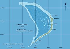
Bokak (znany również jako Taongi) – atol wchodzący w skład Wysp Marshalla o powierzchni 3,2 km² i powierzchni laguny wynoszącej 78 km². Położony jest 680 km na północ od Majuro, innej z wysp łańcucha Ratak Chain. Bokak jest najdalej na północ wysuniętym atolem Wysp Marshalla[1].
Pierwszym Europejczykiem, który odnotował odkrycie tej wyspy był hiszpański podróżnik Alonso de Salazar. Zapis ten pochodzi z 21 sierpnia 1526 roku. Ze względu na izolację wyspa nie ma stałej ludności.
Przypisy
- ↑ Dirk Spennemann, The Marshall Islands - Map of the Marshall Islands, marshall.csu.edu.au, 9 października 2005 [dostęp 2017-06-18] (ang.).
| |||||||||||
Media użyte na tej stronie
Autor: Uwe Dedering, Licencja: CC BY-SA 3.0
Relief location map of Oceania.
- Projection: Lambert azimuthal equal-area projection.
- Area of interest:
- N: 35.0° N
- S: -55.0° N
- W: 110.0° E
- E: 230.0° E (This is -130° E)
- Projection center:
- NS: -10.0° N
- WE: 170.0° E
- GMT projection: -JA170/-5/20c
- GMT region: -R79.58168799459713/-44.42200097096855/-120.83787447194456/33.90289238708686r
- GMT region for grdcut: -R80.0/-63.0/260.0/39.0r
- Relief: SRTM30plus.
- Made with Natural Earth. Free vector and raster map data @ naturalearthdata.com.
Autor: NordNordWest, Licencja: CC BY 3.0
Location map of the Marshall Islands
Autor: Mr Minton from San Diego, US, Licencja: CC BY 2.0
Taongi (Bokak) Atoll EVS precision map, color coded for vegetation, bare land, reef shallows, lagoon, and open ocean.


