Bossier City
 Bossier City | |||
| |||
| Państwo | |||
|---|---|---|---|
| Stan | |||
| Parafia | |||
| Data założenia | 1905 | ||
| Prawa miejskie | 1950 | ||
| Powierzchnia | 109,7 km² | ||
| Populacja (2013) • liczba ludności • gęstość |
| ||
| Nr kierunkowy | 318 | ||
| Kod pocztowy | 71110–71112 | ||
| Strona internetowa | |||
Bossier City – miasto (city) w parafii Bossier, w północno-zachodniej części stanu Luizjana, w Stanach Zjednoczonych, położone na wschodnim brzegu rzeki Red, naprzeciw miasta Shreveport[1]. W 2013 roku miasto liczyło 66 333 mieszkańców[2].
Miejscowość założona została w 1905 roku i nazwana została na cześć XIX-wiecznego kongresmena, Pierre'a Bossiera. Bossier City rozwinęło się po II wojnie światowej, jako ośrodek przemysłu petrochemicznego i włókienniczego. W 1950 roku miejscowość uzyskała status miasta[1].
Na wschodnim skraju miasta znajduje się baza lotnicza Barksdale Air Force Base[1].
Urodzeni w Bossier City
Przypisy
- ↑ a b c Bossier City, [w:] Encyclopædia Britannica [online] [dostęp 2015-01-02] (ang.).
- ↑ Bossier City (city), Louisiana. QuickFacts from the US Census Bureau. [dostęp 2015-01-02]. (ang.).
Media użyte na tej stronie
Autor: Uwe Dedering, Licencja: CC BY-SA 3.0
Location map of the USA (without Hawaii and Alaska).
EquiDistantConicProjection:
Central parallel:
* N: 37.0° N
Central meridian:
* E: 96.0° W
Standard parallels:
* 1: 32.0° N
* 2: 42.0° N
Made with Natural Earth. Free vector and raster map data @ naturalearthdata.com.
Formulas for x and y:
x = 50.0 + 124.03149777329222 * ((1.9694462586094064-({{{2}}}* pi / 180))
      * sin(0.6010514667026994 * ({{{3}}} + 96) * pi / 180))
y = 50.0 + 1.6155950752393982 * 124.03149777329222 * 0.02613325650382181
      - 1.6155950752393982  * 124.03149777329222 *
     (1.3236744353715044  - (1.9694462586094064-({{{2}}}* pi / 180))
      * cos(0.6010514667026994 * ({{{3}}} + 96) * pi / 180))
The flag of Navassa Island is simply the United States flag. It does not have a "local" flag or "unofficial" flag; it is an uninhabited island. The version with a profile view was based on Flags of the World and as a fictional design has no status warranting a place on any Wiki. It was made up by a random person with no connection to the island, it has never flown on the island, and it has never received any sort of recognition or validation by any authority. The person quoted on that page has no authority to bestow a flag, "unofficial" or otherwise, on the island.
Flag of Bossier City
Autor: Alexrk2, Licencja: CC BY 3.0
Ta mapa została stworzona za pomocą GeoTools.
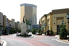
Picture taken by Justin Bryan Galloway of the Forum Newsweekly Magazine in Shreveport, Louisiana. The owner of this photo is the one who uploaded it. Any questions can be directed to justin@theforumnews.com I give full release of this image. Taken August 2005, at the Louisiana Boardwalk in Bossier City, Louisiana.


