Brighton and Hove
| ||||
| ||||
(c) Simon Carey, CC BY-SA 2.0 Brighton | ||||
| Państwo | ||||
| Kraj | ||||
| Region | South East England | |||
| Hrabstwo | East Sussex | |||
| Siedziba | Hove | |||
| Powierzchnia | 87,54 km² | |||
| Populacja (2011) • liczba ludności | 273 400 | |||
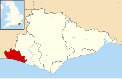
| Położenie na mapie East Sussex Contains Ordnance Survey data © Crown copyright and database right, CC BY-SA 3.0 | ||||
| Portal | ||||
Brighton and Hove – dystrykt o statusie city i unitary authority w hrabstwie ceremonialnym East Sussex w Anglii. Utworzony w 2000 przez połączenie miast Brighton i Hove.
Do innych miejscowości dystryktu należą Hangleton, Ovingdean, Patcham, Portslade, Rottingdean, Saltdean, Stanmer, West Blatchington i Woodingdean.
Media użyte na tej stronie
Flag of England. Saint George's cross (a red cross on a white background), used as the Flag of England, the Italian city of Genoa and various other places.
(c) Simon Carey, CC BY-SA 2.0
Clock Tower Built by the corporation in 1887 to celebrate Queen Victoria's golden jubilee. This view is from Queens Road and looks down West Street to the sea, a route many daytrippers from the station would follow. The road it crosses is North Street a major shopping street in Brighton, the building that is currently occupied by Waterstones was purpose built for Burtons in the late 1920s when West Street was widened and still bears a stone inscription between the roof and top floor windows. Until the 1980s public conveniences were based underneath the tower but have been bricked up and the paved diagonal stretch in front was until the end of the 1990s North Street Quadrant and open to traffic.
Contains Ordnance Survey data © Crown copyright and database right, CC BY-SA 3.0
Map of East Sussex, UK with Brighton and Hove highlighted.
Equirectangular map projection on WGS 84 datum, with N/S stretched 155%


