Bristol (Connecticut)
 | |
| Przydomek: Mum City, Bell City | |
| Państwo | |
|---|---|
| Stan | |
| Hrabstwo | |
| Data założenia | 1785 |
| Prawa miejskie | 1911 |
| Kod statystyczny | |
| Powierzchnia | 69,4 km² |
| Wysokość | 93 m n.p.m. |
| Populacja (2010) • liczba ludności |
|
| Nr kierunkowy | 860 |
| Kod pocztowy | 06010 – 06011 |
| Strefa czasowa | |
| Strona internetowa | |
| Portal | |
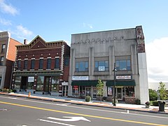
Bristol – miasto w Stanach Zjednoczonych (stan Connecticut), w hrabstwie Hartford, położone nad rzeką Pequabuck[1]. Bristol jest znane przede wszystkim jako siedziba ESPN, którego główne studio jest w mieście[1]. W Bristol znajduje się również jezioro Compounce, najstarszy, wciąż funkcjonowania parku rozrywki w USA. Bristol jest znany również jako historycznym ośrodkiem produkcji zegarków (od 1790)[1][2]. Znajduje się tam amerykańskie muzeum zegarów i zegarków[1][2].
W mieście rozwinął się przemysł metalowy, elektrotechniczny oraz elektroniczny[2].
W 2000 roku w Bristolu mieszkało 60 062 mieszkańców, a w 2010 60 477 osób[1].
Religia
- Parafia św. Stanisława Biskupa i Męczennika w Bristol
Miasta partnerskie
Przypisy
Linki zewnętrzne
- Bristol (Connecticut) w bazie city-data.com (ang.)
Media użyte na tej stronie
Autor: Alexrk2, Licencja: CC BY 3.0
Ta mapa została stworzona za pomocą GeoTools.
Autor: Uwe Dedering, Licencja: CC BY-SA 3.0
Location map of the USA (without Hawaii and Alaska).
EquiDistantConicProjection:
Central parallel:
* N: 37.0° N
Central meridian:
* E: 96.0° W
Standard parallels:
* 1: 32.0° N
* 2: 42.0° N
Made with Natural Earth. Free vector and raster map data @ naturalearthdata.com.
Formulas for x and y:
x = 50.0 + 124.03149777329222 * ((1.9694462586094064-({{{2}}}* pi / 180))
      * sin(0.6010514667026994 * ({{{3}}} + 96) * pi / 180))
y = 50.0 + 1.6155950752393982 * 124.03149777329222 * 0.02613325650382181
      - 1.6155950752393982  * 124.03149777329222 *
     (1.3236744353715044  - (1.9694462586094064-({{{2}}}* pi / 180))
      * cos(0.6010514667026994 * ({{{3}}} + 96) * pi / 180))
The flag of Navassa Island is simply the United States flag. It does not have a "local" flag or "unofficial" flag; it is an uninhabited island. The version with a profile view was based on Flags of the World and as a fictional design has no status warranting a place on any Wiki. It was made up by a random person with no connection to the island, it has never flown on the island, and it has never received any sort of recognition or validation by any authority. The person quoted on that page has no authority to bestow a flag, "unofficial" or otherwise, on the island.
Autor: Doug Kerr, Licencja: CC BY-SA 2.0
Main Street Historic District, Bristol, Connecticut.


