Brookfield (Wisconsin)
| ||||
| ||||
 | ||||
| Państwo | ||||
| Stan | Wisconsin | |||
| Hrabstwo | Waukesha | |||
| Prawa miejskie | 1954 | |||
| Zarządzający | Steven V. Ponto | |||
| Powierzchnia | 70,4 km² | |||
| Wysokość | 253[1] m n.p.m. | |||
| Populacja (2010) • liczba ludności • gęstość | 37 920[2] 210,7 os./km² | |||
| Nr kierunkowy | 262 | |||
| Kod pocztowy | 53005, 53008, 53045 | |||
| Strefa czasowa | UTC-06:00 UTC-05:00 | |||
| Strona internetowa | ||||
| Portal | ||||
Brookfield – miasto w hrabstwie Waukesha w stanie Wisconsin, liczące niespełna 40 tys. mieszkańców. Zajmuje powierzchnię ok. 70 km².
Klimat
Miasto leży w strefie klimatu kontynentalnego, wilgotnego z łagodnym latem i opadami przez cały rok, należącego według klasyfikacji Köppena do strefy Dfb. Średnia temperatura roczna wynosi 12,1°C, a opady 886,5 mm. Średnia temperatura najcieplejszego miesiąca - lipca wynosi 25,4°C, natomiast najzimniejszego -6,8°C. Miesiącem o najwyższych opadach jest maj o średnich opadach wynoszących 116,8 mm, natomiast najniższe opady są w styczniu i wynoszą średnio 35,6[3].
Miasta partnerskie
Przypisy
- ↑ Feature Detail Report for: Brookfield, Wisconsin (ang.). The Geographic Names Information System (GNIS). [dostęp 2018-04-26].
- ↑ Brookfield, Wisconsin Population Census 2010 and 2000 (ang.). CensusViewer. [dostęp 2018-04-26].
- ↑ Climate Summary, Brookfield, Wisconsin (ang.). Weatherbase. [dostęp 2018-04-26].
| ||||||||||
Media użyte na tej stronie
Autor: Alexrk2, Licencja: CC BY 3.0
Ta mapa została stworzona za pomocą GeoTools.
Autor: Uwe Dedering, Licencja: CC BY-SA 3.0
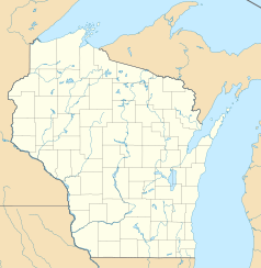
Location map of the USA (without Hawaii and Alaska).
EquiDistantConicProjection:
Central parallel:
* N: 37.0° N
Central meridian:
* E: 96.0° W
Standard parallels:
* 1: 32.0° N
* 2: 42.0° N
Made with Natural Earth. Free vector and raster map data @ naturalearthdata.com.
Formulas for x and y:
x = 50.0 + 124.03149777329222 * ((1.9694462586094064-({{{2}}}* pi / 180))
      * sin(0.6010514667026994 * ({{{3}}} + 96) * pi / 180))
y = 50.0 + 1.6155950752393982 * 124.03149777329222 * 0.02613325650382181
      - 1.6155950752393982  * 124.03149777329222 *
     (1.3236744353715044  - (1.9694462586094064-({{{2}}}* pi / 180))
      * cos(0.6010514667026994 * ({{{3}}} + 96) * pi / 180))
The flag of Navassa Island is simply the United States flag. It does not have a "local" flag or "unofficial" flag; it is an uninhabited island. The version with a profile view was based on Flags of the World and as a fictional design has no status warranting a place on any Wiki. It was made up by a random person with no connection to the island, it has never flown on the island, and it has never received any sort of recognition or validation by any authority. The person quoted on that page has no authority to bestow a flag, "unofficial" or otherwise, on the island.
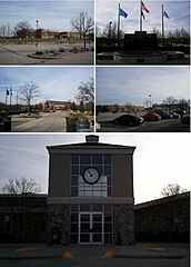
A collage of photos from Brookfield, Wisconsin. From Top left clockwise: Brookfield Square Mall, Veterans Memorial Fountain, City Hall, and Brookfield Central High School
Autor: Oryginalnym przesyłającym był Bumm13 z angielskiej Wikipedii, Licencja: CC-BY-SA-3.0
Adapted from Wikipedia's WI county maps by Bumm13.
Autor: Merenta, Licencja: CC BY-SA 3.0
Historical Marker noting birthplace of Caroline Quiner "Ma" Ingalls, mother of author Laura Ingalls Wilder. This stands in Brookfield, Wisconsin, just NW of the intersection of Brookfield and Davidson Roads. This view is looking approximately due north.


