Brooklands (Trafford)
(c) Manchester Warrior, CC BY-SA 2.0 | |
| Państwo | |
|---|---|
| Kraj | |
| Region | |
| Hrabstwo | |
| Dystrykt | |
| Populacja (2011) • liczba ludności |
|
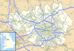
Położenie na mapie Wielkiego Manchesteru Contains Ordnance Survey data © Crown copyright and database right, CC BY-SA 3.0 | |
Położenie na mapie Wielkiej Brytanii (c) Karte: NordNordWest, Lizenz: Creative Commons by-sa-3.0 de | |
| 53,409°N 2,318°W/53,409000 -2,318000 | |
| Portal | |
Brooklands – dzielnica miasta Sale, w Anglii, w hrabstwie Wielki Manchester, w dystrykcie Trafford[1]. Leży 1 km od centrum miasta Sale, 9,2 km od miasta Manchester i 259,6 km od Londynu[2]. W 2011 roku dzielnica liczyła 10 434 mieszkańców[3].
Przypisy
- ↑ Brooklands. Ordnance Survey linked data. [dostęp 2016-12-05]. (ang.).
- ↑ Distance from BROOKLANDS [SJ791905]. GENUKI. [dostęp 2016-12-05]. (ang.).
- ↑ Area: Brooklands (Ward). Neighbourhood Statistics (ONS). [dostęp 2016-12-05]. (ang.).
Media użyte na tej stronie
(c) Karte: NordNordWest, Lizenz: Creative Commons by-sa-3.0 de
Location map of the United Kingdom
Flag of England. Saint George's cross (a red cross on a white background), used as the Flag of England, the Italian city of Genoa and various other places.
(c) Manchester Warrior, CC BY-SA 2.0
Brooklands Metrolink Station Brooklands Station was originally opened on 1st December 1859 as part of the Manchester, South Junction and Altrincham Railway, which on 1st January 1948 became part of British Rail's London Midland Region following nationalisation.
The last day of operation by British Rail was Christmas Eve 1991, and the Station re-opened on Monday 15th June 1992 as part of the Manchester Metrolink tram network.
Pictured above is Light Rail Vehicle No. 1014 at Brooklands Station on Sunday 1st July 2007 which was the last day of tram operation between Manchester and Altrincham before a scheduled eight week closedown for track renewal work.Contains Ordnance Survey data © Crown copyright and database right, CC BY-SA 3.0
Map of Greater Manchester, UK with the following information shown:
- Administrative borders
- Coastline, lakes and rivers
- Roads and railways
- Urban areas
The data includes both primary routes and railway lines.
Equirectangular map projection on WGS 84 datum, with N/S stretched 165%
Geographic limits:
- West: 2.80W
- East: 1.90W
- North: 53.70N
- South: 53.32N


