Buckhurst Hill (stacja metra)
 Budynek stacji Buckhurst Hill, 2009 | |
| Państwo | |
|---|---|
| Miejscowość | |
| Dzielnica | |
| Data otwarcia | 1856 |
| Liczba peronów | 2 |
| Central Line | |
| Poprzednia stacja | |
| Następna stacja | |
Położenie na mapie hrabstwa Essex  Contains Ordnance Survey data © Crown copyright and database right, CC BY-SA 3.0 | |
Położenie na mapie Wielkiej Brytanii  (c) Karte: NordNordWest, Lizenz: Creative Commons by-sa-3.0 de | |
Położenie na mapie Anglii  | |
| Portal | |
Buckhurst Hill – stacja londyńskiego metra położona na trasie Central Line pomiędzy stacjami Woodford a Loughton. Znajduje się w Buckhurst Hill w dystrykcie Epping Forest, w piątej strefie biletowej[1]. W 2010 roku stacja obsłużyła 1,790 miliona pasażerów[2].
Stacja została otwarta 22 sierpnia 1856 przez Eastern Counties Railway, w ramach połączenia z Londynu do Loughton, które to w 1865 roku zostało przedłużone do Epping i Chipping Ongar[3]. 21 listopada 1948 stacja stała się częścią Central Line[4].
Jest to druga stacja Central Line w Buckhurst Hill, obok Roding Valley. Od 2007 roku jest to jedyna stacja wschodniej części linii, znajdująca się w piątej strefie biletowej.
Galeria

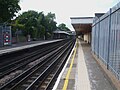
Widok na południe
Widok na północ

Symbol stacji
Przypisy
- ↑ Tube stations - Buckhurst Hill. Transport for London. [dostęp 2012-01-10].
- ↑ Customer metrics: entries and exits. Transport For London. [dostęp 2012-01-12]. (ang.).
- ↑ Railways to Epping & Ongar. The Holden F5 Locomotive Trust. [dostęp 2012-01-12]. (ang.).
- ↑ Central line facts. Transport For London. [dostęp 2012-01-12]. (ang.).
| Linia główna | |
|---|---|
| Odgałęzienie West Ruislip | |
| Odgałęzienie Ealing Broadway | |
| Odgałęzienie Woodford | |
| Odgałęzienie Epping |
![]()
Media użyte na tej stronie
Contains Ordnance Survey data © Crown copyright and database right, CC BY-SA 3.0
Map of Essex, UK with the following information shown:
- Administrative borders
- Coastline, lakes and rivers
- Roads and railways
- Urban areas
Equirectangular map projection on WGS 84 datum, with N/S stretched 160%
Geographic limits:
- West: 0.06W
- East: 1.32E
- North: 52.11N
- South: 51.42N
(c) Karte: NordNordWest, Lizenz: Creative Commons by-sa-3.0 de
Location map of the United Kingdom


Autor: Sunil060902, Licencja: CC BY-SA 3.0
Buckhurst Hill tube station looking westbound (actually south here)

Autor: Sunil060902, Licencja: CC BY-SA 3.0
Buckhurst Hill tube station looking eastbound (actually north here)

Buckhurst Hill Tube Station Sign. Photo by Matt Whitby
Autor: Sunil060902, Licencja: CC-BY-SA-3.0
Buckhurst Hill tube station building