Buckinghamshire
| Hrabstwo ceremonialne | |||||
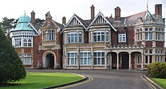
 Bletchley Park – dawna siedziba brytyjskich kryptologów, obecnie na terenie miasta Milton Keynes | |||||
| |||||
| Państwo | |||||
|---|---|---|---|---|---|
| Kraj | |||||
| Region | |||||
| Siedziba | |||||
| Powierzchnia | 1874 km² | ||||
| Populacja (2011) • liczba ludności |
| ||||
| • gęstość | 402,4 os./km² | ||||
| Szczegółowy podział administracyjny | |||||
 | |||||
| Liczba unitary authorities | 2 | ||||
Położenie na mapie | |||||
| Strona internetowa | |||||
| Portal | |||||
Buckinghamshire – hrabstwo ceremonialne i historyczne w środkowej Anglii, w regionie South East England, położone na północny zachód od Londynu, obejmujące dwie jednostki administracyjne typu unitary authority – Buckinghamshire oraz Milton Keynes. Do 2020 roku Buckinghamshire pełniło funkcję administracyjną jako hrabstwo niemetropolitalne, z ośrodkiem administracyjnym w Aylesbury[1]. Historyczną stolicą hrabstwa było Buckingham.
Powierzchnia hrabstwa wynosi 1874 km², a liczba mieszkańców – 754 100 mieszkańców (2011)[2]. Największym miastem jest Milton Keynes, powstałe jako jedno z tzw. „nowych miast” (new town) w latach 60. XX wieku. Innymi większymi miastami na terenie hrabstwa są High Wycombe, Aylesbury, Bletchley, Amersham oraz Chesham[3].
Przez Buckinghamshire przebiega pasmo wzgórz Chiltern Hills, uznane za obszar o wybitnym pięknie naturalnym (Area of Outstanding Natural Beauty).
Na terenie hrabstwa leży posiadłość Bletchley Park, która podczas II wojny światowej była siedzibą brytyjskich kryptologów, pracujących dla Rządowej Szkoły Kodów i Szyfrów.
Na północy Buckinghamshire graniczy z hrabstwem Northamptonshire, na północnym wschodzie z Bedfordshire, na wschodzie z Hertfordshire, na południowym wschodzie z Wielkim Londynem, na południu z Berkshire a na zachodzie z Oxfordshire.
Podział administracyjny
Obecny
Hrabstwo ceremonialne obejmuje dwie jednostki administracyjne typu unitary authority:
- Buckinghamshire
- Milton Keynes
Do 2020 roku
Do kwietnia 2020 roku[1] Buckinghamshire było hrabstwem niemetropolitalnym, w skład którego wchodziły cztery dystrykty. Jako hrabstwo ceremonialne Buckinghamshire obejmowało dodatkowo jedną jednostkę unitary authority:
- South Bucks
- Chiltern
- Wycombe
- Aylesbury Vale
- Milton Keynes (unitary authority)
Mapa
Przypisy
- ↑ a b Elections 2021: Buckinghamshire votes in council and PCC elections. BBC News, 2021-05-07. [dostęp 2022-06-18]. (ang.).
- ↑ Table P04 2011 Census: Usual resident population by five-year age group, local authorities in England and Wales. Office for National Statistics. [dostęp 2012-07-24]. (ang.).
- ↑ a b Office for National Statistics: KS101EW - Usual resident population. [w:] 2011 Census [on-line]. Nomis – Official labour market statistics, 2013-02-12. [dostęp 2022-06-05]. (ang.).
- ↑ Office for National Statistics: Built-up Area to Local Authority District (December 2011) Lookup in England and Wales. [w:] Open Geography Portal [on-line]. [dostęp 2022-06-05]. (ang.).
- ↑ Office for National Statistics: Built-up Area Sub Divisions (December 2011) Boundaries. [w:] Open Geography Potal [on-line]. [dostęp 2022-06-05]. (ang.).
Bibliografia
- Buckinghamshire, [w:] Encyclopædia Britannica [online] [dostęp 2011-11-28] (ang.).
Media użyte na tej stronie
Flag of England. Saint George's cross (a red cross on a white background), used as the Flag of England, the Italian city of Genoa and various other places.
Bletchley Park mansion. Bletchley Park was the place where Enigma messages were cracked during the World War 2. By Matt Crypto.
Autor: Rcsprinter123, Licencja: CC BY 3.0
Numbered districts of Buckinghamshire ceremonial county (from 2020). Derived from File:Buckinghamshire UK district map (blank).svg, by Nilfanion.
- Buckinghamshire
- Milton Keynes
Autor: Nilfanion, Licencja: CC BY-SA 3.0
Location of the ceremonial county of Buckinghamshire within England.
Autor:
- County_Flag_of_Buckinghamshire.png: Jza84
- derivative work: Urutseg (talk)
The County Flag of Buckinghamshire', a modified banner of arms of Buckinghamshire County Council.
Contains Ordnance Survey data © Crown copyright and database right, CC BY-SA 3.0
Map of Buckinghamshire, UK with the following information shown:
- Administrative borders
- Coastline, lakes and rivers
- Roads and railways
- Urban areas
Equirectangular map projection on WGS 84 datum, with N/S stretched 160%
Geographic limits:
- West: 1.33W
- East: 0.33W
- North: 52.21N
- South: 51.47N


