Bur Fu’ad
| ||
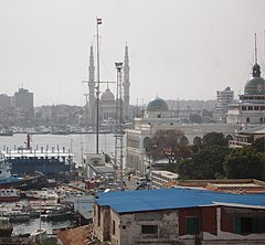
 Widok na miasto od strony zachodniej, z Port Said | ||
| Państwo | ||
| Muhafaza | Port Said | |
| Populacja (2006) • liczba ludności | 70 417[1] | |
Położenie na mapie Egiptu (c) Karte: NordNordWest, Lizenz: Creative Commons by-sa-3.0 de | ||
Bur Fu’ad, Port Fuad (arab. بور فؤاد) – miasto portowe, leżące na północnym wschodzie Egiptu, w muhafazie Port Said nad Morzem Śródziemnym, nad Kanałem Sueskim, na azjatyckim Synaju, na wschód od miasta Port Said.
W rzeczywistości miasto znajduje się na sztucznej trójkątnej wyspie, oddzielone Kanałem Sueskim (prawobrzeżnym i lewobrzeżnym wyjściem i wejściem do kanału). Z północy leży bezpośrednio przy Morzu Śródziemnym. Południowa i środkowa część wyspy rozdzielone są tzw. Kanałem Nowym – małym kanałem łączącym obie odnogi Kanału Sueskiego. Tereny zabudowane są zlokalizowane na północno-zachodniej części wyspy.
Miasto zostało założone w 1927 roku jako osiedle kadry urzędniczej dla przeludniającego się w tym czasie Port Saidu. Nazwa miasta nadana została na cześć pierwszego króla Egiptu w epoce nowożytnej – Fu’ada I. Zabudowa miasta pochodzi głównie z lat 30 XX w., składa się z kolonialnych willi i ogrodów. Na północy miasta znajduje się basen jachtowy i połączenie promowe z Port Saidem. Ludność miasta w większości zatrudniona jest w porcie i przy obsłudze Kanału Sueskiego. W mieście znajduje się szpital. Bur Fu’ad i Port Said tworzą jeden obszar aglomeracyjny.
Kryzys sueski
6 listopada 1956 roku, w popołudniowym ataku lotniczym na Egipt, Francuzi i Brytyjczycy wykonali desant, zajmując Bur Fu’ad. Dopiero po wystąpieniu ZSRR i USA przerwano walki i wycofano wojska. Po wojnie miasto było pod kontrolą ONZ.
Wojna sześciodniowa
Od czerwca 1967 roku miasto było pod kontrolą Izraela. Po wojnie Jom Kipur ostatnie oddziały izraelskie wycofały się z tego terenu do 5 marca 1974 roku.
Przypisy
Bibliografia
Media użyte na tej stronie
Port Fouad as seen from Port Said on the west bank of Suez canal.
Autor: Hajotthu, Licencja: CC BY 3.0
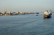
Einfahrt in den Suezkanal bei Port Said, im Hintergrund Port Fouad mit seiner "Großen Moschee"
(c) Karte: NordNordWest, Lizenz: Creative Commons by-sa-3.0 de
Location map of Egypt
Port Said and the entrance to the Suez Canal. Photographed from the International Space Station.
- Ship Traffic on the Suez Canal, Egypt
- This astronaut photograph captures a northbound convoy of cargo ships entering the Mediterranean Sea from the Suez Canal in Egypt (leftmost canal branch at image center). The Suez Canal connects Port Said on the Mediterranean Sea with the port of Suez on the Red Sea, and provides an essentially direct route for transport of goods between Europe and Asia. The Canal is 163 kilometers (approximately 100 miles) long, and 300 meters (almost 1,000 feet) wide at its narrowest point—wide enough for ships as large as aircraft carriers to traverse it. Transit time from end to end is 14 hours on average.
- The Canal was built under the direction of Ferdinand de Lesseps of France using primarily Egyptian labor, and it was opened to traffic in 1869. Subsequent wars and skirmishes have passed control of the Canal to various powers including the United Kingdom, Egypt, Israel, and the United Nations. A multinational observer force including the United States, Israel, and Egypt currently oversees the Canal.
- This is an oblique image of the canal, meaning it has been taken at an angle. Astronauts and cosmonauts on the International Space Station (ISS) can photograph the part of the Earth directly below the station as it passes overhead, or they can photograph different parts of the globe. When they photograph different parts of the globe, they take pictures at an angle to provide a sense of perspective. In this case, the ISS was located above the eastern coast of Cyprus, and the astronaut was looking at Egypt to the southwest. Regions of reduced clarity in the image result from thin cloud cover. The day this image was taken, the total number of Earth photographs acquired by astronauts aboard the ISS passed 200,000.


