Burton upon Trent
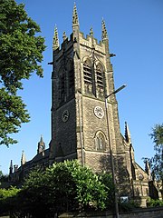
(c) Alan Slater, CC BY-SA 2.0 All Saints' Church, Burton upon Trent | |
| Państwo | |
|---|---|
| Kraj | |
| Region | West Midlands |
| Hrabstwo | |
| Populacja (2001) • liczba ludności |
|
| Nr kierunkowy | 01283 |
| Kod pocztowy | DE13-DE15 |
Położenie na mapie Staffordshire Contains Ordnance Survey data © Crown copyright and database right, CC BY-SA 3.0 | |
Położenie na mapie Wielkiej Brytanii (c) Karte: NordNordWest, Lizenz: Creative Commons by-sa-3.0 de | |
| Portal | |
Burton upon Trent (Burton-on-Trent, Burton) – miasto w Wielkiej Brytanii (Anglia), na wschodzie hrabstwa Staffordshire, nad rzeką Trent. W 2001 roku miasto liczyło 65 769 mieszkańców[1].
Jego początek sięga XVI w., kiedy było osadą przy klasztorze benedyktynów Saint Modwen. Jest centrum administracyjnym regionu East Staffordshire. W okolicach miasta znajdują się m.in. takie zabytki jak: Calke Abbey, Catton Hall, Elvaste Castle czy Repton School.
Gospodarka
W mieście działa pięć browarów:
- Coors Brewers Limited - dawniej Bass Brewers Limited, produkuje takie marki jak: Carling, Coors, Worthington Bitter
- Marstons, Thompson and Evershed plc - produkuje m.in. Bassa na licencji InBev.
- Burton Bridge Brevery - browar lokalny
- Tower Brewery
- Cottage Brewery oparty na Old Cottage Inn.
W Burton znajduje się również muzeum browarnictwa. Łączność między przemysłem browarniczym a miastem symbolizuje rzeźba Cooper Burton znajdująca się w jednym z centrów handlowych. W okolicach Burton znajdują się fabryki firm: Toyota, Nestlé czy Pirelli.
Sport
W mieście działają następujące instytucje sportowe:
- Burton Albion - drużyna piłkarska
- klub rugby,
- regionalna liga krykieta,
- Branston Golf Club - w dzielnicy Branston.
Komunikacja
Parę kilometrów od Burton znajduje się autostrada A38. Najbliżej położone miasta to Derby 17 km, Birmingham 40km, Leicester 43 km, Stoke on Trent 50 km. Najbliższe lotniska: East Midlands 21 km, międzynarodowe lotnisko Birmingham 40 km, lotnisko Nottingham 50 km.
Przypisy
- ↑ KS01 Usual resident population: Census 2001, Key Statistics for urban areas (ang.). Office for National Statistics. [dostęp 2016-04-29]. [zarchiwizowane z tego adresu (2004-07-23)].
Media użyte na tej stronie
(c) Karte: NordNordWest, Lizenz: Creative Commons by-sa-3.0 de
Location map of the United Kingdom
Redirect arrow, to be used in redirected articles in Wikipedias written from left to right. Without text.
Flag of England. Saint George's cross (a red cross on a white background), used as the Flag of England, the Italian city of Genoa and various other places.
(c) Alan Slater, CC BY-SA 2.0
All Saints' parish church, Branstone Road, Burton upon Trent, Staffordshire, seen from the north
Contains Ordnance Survey data © Crown copyright and database right, CC BY-SA 3.0
Map of Staffordshire, UK with the following information shown:
- Administrative borders
- Coastline, lakes and rivers
- Roads and railways
- Urban areas
Equirectangular map projection on WGS 84 datum, with N/S stretched 165%
Geographic limits:
- West: 2.50W
- East: 1.40W
- North: 53.25N
- South: 52.40N


