Bury (Wielki Manchester)
(c) robert wade, CC BY-SA 2.0 | |
| Państwo | |
|---|---|
| Kraj | |
| Hrabstwo ceremonialne | |
| Unitary authority | |
| Populacja (2001) • liczba ludności |
|
| Nr kierunkowy | 0161 |
| Kod pocztowy | BL9 |
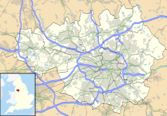
Położenie na mapie Wielkiego Manchesteru Contains Ordnance Survey data © Crown copyright and database right, CC BY-SA 3.0 | |
Położenie na mapie Wielkiej Brytanii (c) Karte: NordNordWest, Lizenz: Creative Commons by-sa-3.0 de | |
| Strona internetowa | |
| Portal | |
Bury – miasto w północno-zachodniej Anglii, położone w północnej części obszaru metropolitalnego Wielkiego Manchesteru, w dystrykcie (unitary authority) Bury[1], pomiędzy Rochdale a Bolton, nad rzeką Irwell. W 2001 roku miasto liczyło 60 718 mieszkańców[2].
Dawniej ośrodek przemysłu włókienniczego, obecnie gospodarka miasta oparta na usługach oraz przemyśle papierniczym, chemicznym i spożywczym. Dobrze rozbudowana sieć komunikacji z pobliskimi miastami, m.in. szybki tramwaj Metrolink łączący Bury z Manchesterem.
W centrum miasta znajduje się typowy dla Lancashire rynek, słynny ze sprzedaży tradycyjnej w tym rejonie kaszanki (ang. „black pudding”), istniejący w tym samym miejscu od 1444.
Największą atrakcję turystyczną Bury stanowi, obsługiwana przez zabytkowe pociągi, linia kolejowa East Lancashire Railway – wraz z kolekcją lokomotyw oraz autobusów miejskich w Bury Transport Museum[3].
Miasta partnerskie
Przypisy
- ↑ Geograph
- ↑ KS01 Usual resident population: Census 2001, Key Statistics for urban areas (ang.). Office for National Statistics. [dostęp 2016-01-23]. [zarchiwizowane z tego adresu (2004-07-23)].
- ↑ Bury Transport Museum
Media użyte na tej stronie
(c) Karte: NordNordWest, Lizenz: Creative Commons by-sa-3.0 de
Location map of the United Kingdom
Flag of England. Saint George's cross (a red cross on a white background), used as the Flag of England, the Italian city of Genoa and various other places.
The flag of Navassa Island is simply the United States flag. It does not have a "local" flag or "unofficial" flag; it is an uninhabited island. The version with a profile view was based on Flags of the World and as a fictional design has no status warranting a place on any Wiki. It was made up by a random person with no connection to the island, it has never flown on the island, and it has never received any sort of recognition or validation by any authority. The person quoted on that page has no authority to bestow a flag, "unofficial" or otherwise, on the island.
Contains Ordnance Survey data © Crown copyright and database right, CC BY-SA 3.0
Map of Greater Manchester, UK with the following information shown:
- Administrative borders
- Coastline, lakes and rivers
- Roads and railways
- Urban areas
The data includes both primary routes and railway lines.
Equirectangular map projection on WGS 84 datum, with N/S stretched 165%
Geographic limits:
- West: 2.80W
- East: 1.90W
- North: 53.70N
- South: 53.32N


