Buszehr (ostan)
| ostan | |
(c) Hadi Karimi, CC BY 3.0 | |
| Państwo | |
|---|---|
| Siedziba | Buszehr |
| Powierzchnia | 22 742,7 km²[1] |
| Populacja (2011) • liczba ludności |
|
| • gęstość | 45 os./km² |
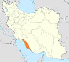
Położenie na mapie Iranu | |
Buszehr (per. استان بوشهر) – ostan w południowo-zachodnim Iranie nad Zatoką Perską. Stolicą jest Buszehr.
Geografia
Ostan Buszehr położony jest w południowo-zachodnim Iranie w obrębie drugiego regionu administracyjnego[2]. Od północy graniczy z ostanami Chuzestan i Kohgiluje wa Bujerahmad, od wschodu z Farsem, od południa z Hormozganem, a od zachodu leży nad wodami Zatoki Perskej. W jego skład wchodzą wyspy Dżazire-je Chark, Dżazire-je Charku, Dżazire-je Szif, Dżazire-je Abbasak i Dżazire-je Negin[3]. Zajmuje powierzchnię 22 742,7 km²[1].
Demografia
W 1996 roku ostan ten zamieszkiwało 743 675, z których 55,3% zamieszkiwało miasta, 44,8% wsie, a 0,2% stanowiły osoby nieosiedlone[4]. Według spisu ludności z 2006 roku ostan Buszehr zamieszkiwało 886 267 osób. Spis ludności z 2011 roku podaje 1 032 949 mieszkańców, co stanowi 1,37% populacji Iranu. Wśród tych osób 560 955 stanowili mężczyźni, a 471 994 kobiety. 72% stanowiła ludność w wieku 15-64 lat, 24,1% w wieku do lat 14, a 3,9% w wieku lat 65 i starsi[1].
Przypisy
- ↑ a b c Statistical Center of Iran: National Population and Housing Census 2011 (1390): Selected Findings (ang.). The President’s Office Deputy of Strategic Planning and Control. [dostęp 2014-10-23].
- ↑ همشهری آنلاین-استانهای کشور به ۵ منطقه تقسیم شدند (Provinces were divided into 5 regions). „Hamshahri Online”, 22-06-2014 (1 Tir 1393, Jalaali). ISSN 1735-6393 (pers.). [zarchiwizowane z adresu 23-06-2014].
- ↑ Bushehr Province. W: Google Maps [on-line]. [dostęp 2014-10-23].
- ↑ Bushehr. Location and Climate. ISTA Inc.. [dostęp 2014-10-23]. [zarchiwizowane z tego adresu (11-04-2014)].
Media użyte na tej stronie
State emblem of the Islamic Republic of Iran. U+262B, stylized version of Arabic script of Allah (الله, with the central lam shaped to look like a sword.) The emblem is also an overlaid rendering of La Ilaha Illa Allah (There is only one God and that is 'Allah'). The exact shape of the emblem and an algorithmic ruler-and-compass construction is described in the national Iranian standard at IRANIAN ISLAMIC REPUBLIC FLAG, ISIRI 1, 1371, 3rd edition, March 1993 in Persian. The emblem was designed by Hamid Nadimi, and was officially approved by Ayatollah Khomeini on May 9, 1980.
(c) Hadi Karimi, CC BY 3.0
Persian Gulf, Mangrove jungle in Asalouyeh, Asaluyeh County, Bushehr Province, Iran
Autor: Original work by Uwe Dering. Highlighted by Dr. Blofeld, Licencja: CC BY-SA 3.0
Locator map of Iran
State emblem of the Islamic Republic of Iran. U+262B, stylized version of Arabic script of Allah (الله, with the central lam shaped to look like a sword.) The emblem is also an overlaid rendering of La Ilaha Illa Allah (There is only one God and that is 'Allah'). The exact shape of the emblem and an algorithmic ruler-and-compass construction is described in the national Iranian standard at IRANIAN ISLAMIC REPUBLIC FLAG, ISIRI 1, 1371, 3rd edition, March 1993 in Persian. The emblem was designed by Hamid Nadimi, and was officially approved by Ayatollah Khomeini on May 9, 1980.


