Butare
 | |
| Państwo | |
|---|---|
| Prowincja | |
| Populacja (2012) • liczba ludności |
|
Butare (do 1962 Astrida) – miasto w południowej Rwandzie, w Prowincji Południowej, stolica dystryktu Huye. 50 220 mieszkańców (2012). Czwarte pod względem liczby mieszkańców miasto kraju. W Butare działał Narodowy Uniwersytet Rwandy, założony w 1963 roku[1]. Miasto jest siedzibą katolickiej diecezji.
Przypisy
- ↑ Gospodarka. Karmelitański Serwis Misyjny. [dostęp 2019-05-27]. (pol.).
Media użyte na tej stronie
Autor: Amakuru, Licencja: CC-BY-SA-3.0
National Museum of Rwanda, Butare, Rwanda
Flag of Rwanda. The flag ratio is 2:3 with the stripes being 2:1:1. Colors are the following officially: Pantone 299 C 2X (blue), RAL 6029 (green), RAL 1023 (yellow) and RAL 1003 (golden yellow). (As of 03/08/2010, the only color used is the Pantone 299 C, which is from here. The rest of the colors are RAL shades from here.)
Autor: Rytc, Licencja: CC BY 3.0
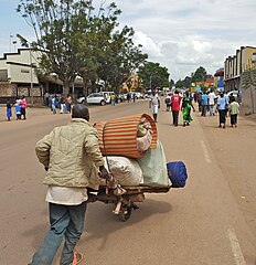
This is take in Butare/Huye in Southern Rwanda of the main street.


