Cáceres (Mato Grosso)
 | |||||
| Państwo | |||||
|---|---|---|---|---|---|
| Stan | |||||
| Data założenia | 1778 | ||||
| Burmistrz | Túlio Aurélio Campos Fontes | ||||
| Powierzchnia | 24398,399 km² | ||||
| Wysokość | 176 m n.p.m. | ||||
| Populacja (2009) • liczba ludności • gęstość |
| ||||
| Nr kierunkowy | 65 | ||||
| Kod pocztowy | 78200-000 | ||||
| Strona internetowa | |||||
Cáceres – miasto i gmina w Brazylii, w stanie Mato Grosso.
Przypisy
Media użyte na tej stronie
Flag of the State of Mato Grosso, Brazil.
Autor:
- MatoGrosso_MesoMicroMunicip.svg: Raphael Lorenzeto de Abreu
- derivative work: Milenioscuro (talk)
Location map of Mato Grosso state. Equirectangular projection, N/S stretching 103 %. Geographic limits of the map:
- N: 7.18° S
- S: 18.19° S
- W: 61.89° W
- E: 49.95° W
Autor: Pedro Spoladore (own work), Licencja: CC-BY-SA-3.0
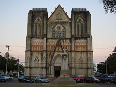
Catedral de São Luís, da Diocese de São Luís de Cáceres-MT. À frente, o Marco do Jaurú.


