Calabasas
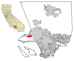
 Położenie na mapie hrabstwa Los Angeles | |||
| |||
| Państwo | |||
|---|---|---|---|
| Stan | |||
| Hrabstwo | Los Angeles | ||
| Burmistrz | James Bozajian[1] | ||
| Powierzchnia | 35,53 km² | ||
| Populacja (2010) • liczba ludności • gęstość | 23 058 649 os./km² | ||
| Nr kierunkowy | 818 | ||
| Kod pocztowy | 91301, 91302, 91372[2] | ||
| Strona internetowa | |||
| Portal | |||
Calabasas – miasto w hrabstwie Los Angeles w Kalifornii. W 2010 było zamieszkiwane przez 23 058 osób[3].
Etymologia nazwy
Nazwa Calabasas pochodzi prawdopodobnie od hiszpańskiego calabaza (dynia, kabaczek bądź tykwa) lub angielskiego słowa calabash również oznaczającego tykwę[4]. W Calabasas jest organizowany Pumpkin Festival odbywający się w październiku w celu uhonorowania dyni, od której przypuszczalnie pochodzi nazwa.
Stałe imprezy
Transport publiczny
W mieście jeżdżą autobusy i trambusy[8].
Ekonomia
Według sprawozdania finansowego miasta z 2009 głównymi pracodawcami w Calabasas są[9]:
- Las Virgenes Unified School District (1672 zatrudnionych)
- Countrywide Home Loans, Inc. (700 zatrudnionych)
- Cheesecake Factory, Inc. (640 zatrudnionych)
- Alcatel Internetworking, Inc. (373 zatrudnionych)
- Sedgwick Claims Management (350 zatrudnionych)
- Viewpoint Education Foundation (275 zatrudnionych)
- Spirent Communications (210 zatrudnionych)
- City of Calabasas (199 zatrudnionych)
- Informa Research Services, Inc. (173 zatrudnionych)
- Valley Crest Co. (160 zatrudnionych)
Znani mieszkańcy
W Calabasas mieszkają m.in.:
- Gary Sinise[11]
- Nikki Sixx[11]
- Kim Kardashian[11]
- Kourtney Kardashian – celebrytka, modelka, biznesmenka, osobowość telewizyjna
- The Kardashians
- Rebecca Romijn[11]
- Jerry O’Connell[11]
- Kendra Wilkinson[11]
- Drake[11]
- Jennifer Lopez[11]
- Ozzy Osbourne[11]
- Dwayne Johnson[11]
- Sean Astin[12]
- Dylan i Cole Sprouse
- Selena Gomez[13]
- Kylie Jenner
- Jeffree Star
Przypisy
- ↑ James Robert Bozajian (ang.). cityofcalabasas.com. [dostęp 2016-06-09]. [zarchiwizowane z tego adresu (2016-05-26)].
- ↑ Look Up a ZIP Code™ – Calabasas, CA (ang.). usps.com. [dostęp 2013-08-25].
- ↑ California Trend Report 2: State and Complete Places (ang.). mcdc.missouri.edu. [dostęp 2013-10-06]. [zarchiwizowane z tego adresu (2011-08-17)].
- ↑ The Great Pumpkin (ang.). calabasaspumpkinfestival.com. [dostęp 2013-08-25].
- ↑ Eggstravaganza Egg Hunt (ang.). cityofcalabasas.com. [dostęp 2013-08-25]. [zarchiwizowane z tego adresu (2015-02-01)].
- ↑ Calabasas Art Festival (ang.). calabasasartscouncil.com. [dostęp 2013-08-25]. [zarchiwizowane z tego adresu (2013-08-26)].
- ↑ July 4th Fireworks Spectacular (ang.). cityofcalabasas.com. [dostęp 2013-08-25]. [zarchiwizowane z tego adresu (2013-08-26)].
- ↑ Transportation/Transit Division (ang.). cityofcalabasas.com. [dostęp 2013-08-25]. [zarchiwizowane z tego adresu (2013-08-26)].
- ↑ City of Calabasas: Principal Employers – Fiscal Year 2009 (ang.). cityofcalabasas.com. [dostęp 2013-10-22]. [zarchiwizowane z tego adresu (2014-05-28)].
- ↑ Jak oni mieszkają! (pol.). gala.pl, 2012-01-09. s. 2. [dostęp 2013-08-25].
- ↑ a b c d e f g h i j k Adrian Glick Kudler: Why Do Bieber and These 25 Other Celebs Live in Calabasas? (ang.). la.curbed.com, 2012-05-31. [dostęp 2013-08-25].
- ↑ 2013 Disneyland 10k (ang.). trackshack.com. [dostęp 2013-10-22].
- ↑ Zoe Shenton: Selena Gomez splashes out $3 million on a new pad in Calabasas - weeks after Justin Bieber sells his (ang.). mirror.co.uk, 2014-03-29. [dostęp 2014-05-07].
Linki zewnętrzne
Media użyte na tej stronie
The flag of Navassa Island is simply the United States flag. It does not have a "local" flag or "unofficial" flag; it is an uninhabited island. The version with a profile view was based on Flags of the World and as a fictional design has no status warranting a place on any Wiki. It was made up by a random person with no connection to the island, it has never flown on the island, and it has never received any sort of recognition or validation by any authority. The person quoted on that page has no authority to bestow a flag, "unofficial" or otherwise, on the island.
Autor: Alexrk2, Licencja: CC BY 3.0
Ta mapa została stworzona za pomocą GeoTools.
Flag of California. This version is designed to accurately depict the standard print of the bear as well as adhere to the official flag code regarding the size, position and proportion of the bear, the colors of the flag, and the position and size of the star.
This map shows the incorporated areas in Los Angeles County, California. :*Calabasas is highlighted in red, in the western San Fernando Valley.
I created it in Inkscape using data from the Los Angeles County Website (Los Angeles County Incorporated Area and District Map (PDF).Autor: Uwe Dedering, Licencja: CC BY-SA 3.0
Location map of the USA (without Hawaii and Alaska).
EquiDistantConicProjection:
Central parallel:
* N: 37.0° N
Central meridian:
* E: 96.0° W
Standard parallels:
* 1: 32.0° N
* 2: 42.0° N
Made with Natural Earth. Free vector and raster map data @ naturalearthdata.com.
Formulas for x and y:
x = 50.0 + 124.03149777329222 * ((1.9694462586094064-({{{2}}}* pi / 180))
      * sin(0.6010514667026994 * ({{{3}}} + 96) * pi / 180))
y = 50.0 + 1.6155950752393982 * 124.03149777329222 * 0.02613325650382181
      - 1.6155950752393982  * 124.03149777329222 *
     (1.3236744353715044  - (1.9694462586094064-({{{2}}}* pi / 180))
      * cos(0.6010514667026994 * ({{{3}}} + 96) * pi / 180))
Autor: NordNordWest, Licencja: CC BY 3.0
Location map of California, USA


