Châtillon-Coligny
| miejscowość i gmina | |||
 Châtillon-Coligny | |||
| |||
| Państwo | |||
|---|---|---|---|
| Region | |||
| Departament | |||
| Okręg | |||
| Kod INSEE | 45085 | ||
| Powierzchnia | 25,37 km² | ||
| Populacja (2006) • liczba ludności |
| ||
| • gęstość | 74 os./km² | ||
| Kod pocztowy | 45230 | ||
| Portal | |||
Châtillon-Coligny – miejscowość i gmina we Francji, w Regionie Centralnym, w departamencie Loiret. Jej burmistrzem jest od 2008 r. Claude Loiseau.
Według danych na rok 1990 gminę zamieszkiwały 1903 osoby, a gęstość zaludnienia wynosiła 75 osób/km² (wśród 1842 gmin Regionu Centralnego Châtillon-Coligny plasowała się wtedy na 205. miejscu pod względem liczby ludności, natomiast pod względem powierzchni na miejscu 483.).
Bibliografia
- Francuski urząd statystyczny. (fr.).
Media użyte na tej stronie
Autor: User:Bourrichon modified by User:Edouard-rainaut, Licencja: CC BY-SA 3.0
Blank administrative map of the department of en:Loiret, France, for geo-location purpose.
Autor: Superbenjamin, Licencja: CC BY-SA 4.0
Blank administrative map of France for geo-location purpose, with regions and departements distinguished. Approximate scale : 1:3,000,000
Autor: Flappiefh, Licencja: CC BY-SA 4.0
Carte administrative vierge de la région Centre-Val de Loire, France, destinée à la géolocalisation.
Autor: Alvaro, Licencja: CC BY-SA 3.0
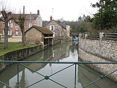
Châtillon-Coligny, Loiret, France. Boulevard de la République, at the corner of the restaurant "Le Coligny". An arm of the Loing river, looking downstream as it's leeaving the moat that runs against what used to be the town defence wall (the moat is immediately upstream from this bridge, behind us).


