Châtonnay
| miejscowość i gmina | |
 | |
| Państwo | |
|---|---|
| Region | |
| Departament | |
| Okręg | |
| Kod INSEE | 38094 |
| Mer | Guy Servet |
| Powierzchnia | 31,93 km² |
| Populacja (1999) • liczba ludności |
|
| • gęstość | 44 os./km² |
| Kod pocztowy | 38440 |
Położenie na mapie Isère  | |
Położenie na mapie Francji  | |
Położenie na mapie regionu Owernia-Rodan-Alpy  | |
| Portal | |
Châtonnay – miejscowość i gmina we Francji, w regionie Owernia-Rodan-Alpy, w departamencie Isère. Jej burmistrzem jest od 2008 r. Guy Servet.
Według danych na rok 1990 gminę zamieszkiwało 1341 osób, a gęstość zaludnienia wynosiła 42 osób/km² (wśród 2880 gmin regionu Rodan-Alpy Châtonnay plasowała się wtedy na 627. miejscu pod względem liczby ludności, natomiast pod względem powierzchni na miejscu 187.).
Bibliografia
- Francuski urząd statystyczny. (fr.).
Media użyte na tej stronie
Isere department location map.svg
Autor: Pedro38, Licencja: CC BY-SA 3.0
Blank administrative map of the department of Isère, France, for geo-location purpose.
Autor: Pedro38, Licencja: CC BY-SA 3.0
Blank administrative map of the department of Isère, France, for geo-location purpose.
France location map-Regions and departements-2016.svg
Autor: Superbenjamin, Licencja: CC BY-SA 4.0
Blank administrative map of France for geo-location purpose, with regions and departements distinguished. Approximate scale : 1:3,000,000
Autor: Superbenjamin, Licencja: CC BY-SA 4.0
Blank administrative map of France for geo-location purpose, with regions and departements distinguished. Approximate scale : 1:3,000,000
Auvergne-Rhône-Alpes region location map.svg
Autor: Flappiefh, Licencja: CC BY-SA 4.0
Carte administrative vierge de la région Auvergne-Rhône-Alpes, France, destinée à la géolocalisation.
Autor: Flappiefh, Licencja: CC BY-SA 4.0
Carte administrative vierge de la région Auvergne-Rhône-Alpes, France, destinée à la géolocalisation.
.svg)
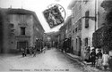
Chatonnay, place de l'église en 1913, p 51 de L'Isère les 533 communes - B.F. Paris.tif
Châtonnay, place de l'église en 1913, p 51 de L'Isère les 533 communes - B.F. de Paris
Châtonnay, place de l'église en 1913, p 51 de L'Isère les 533 communes - B.F. de Paris