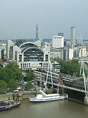
Charing Cross Station
| ||
 Stacja widziana z London Eye | ||
| Państwo | ||
| Miejscowość | Londyn | |
| Lokalizacja | City of Westminster | |
| Zarządca | ||
| Data otwarcia | 1864 | |
| Dane techniczne | ||
| Liczba peronów | 6 | |
| Kasy | ||
Położenie na mapie City of Westminster Contains Ordnance Survey data © Crown copyright and database right, CC BY-SA 3.0 | ||
Położenie na mapie Wielkiej Brytanii (c) Karte: NordNordWest, Lizenz: Creative Commons by-sa-3.0 de | ||
Położenie na mapie Wielkiego Londynu Contains Ordnance Survey data © Crown copyright and database right, CC BY-SA 3.0 | ||
| Portal | ||
Charing Cross Station – stacja kolejowa znajdująca się w centrum Londynu, w dzielnicy City of Westminster. Stacja została otwarta w 1864, obecnie posiada 6 peronów i obsłużyła w 2005 4,825 mln pasażerów.
Poza godzinami szczytu, ze stacji odjeżdżają średnio 33 pociągi na godzinę. Operatorem większości z nich jest firma Southeastern, która jeździ stąd do następujących miast:
Ponadto średnio ze stacji odjeżdżają średnio dwa pociągi na godzinę do Tattenham, których operatorem jest firma Southern.
Linki zewnętrzne
Media użyte na tej stronie
Contains Ordnance Survey data © Crown copyright and database right, CC BY-SA 3.0
Blank map of the City of Westminster, showing electoral wards.
Equirectangular map projection on WGS 84 datum, with N/S stretched 160%
Geographic limits:
- West: 0.22W
- East: 0.1W
- North: 51.55N
- South: 51.48N
(c) Karte: NordNordWest, Lizenz: Creative Commons by-sa-3.0 de
Location map of the United Kingdom
Contains Ordnance Survey data © Crown copyright and database right, CC BY-SA 3.0
Map of Greater London, UK with the following information shown:
- Administrative borders
- Coastline, lakes and rivers
- Roads and railways
- Urban areas
The data includes both primary routes and railway lines.
Equirectangular map projection on WGS 84 datum, with N/S stretched 160%
Geographic limits:
- West: 0.57W
- East: 0.37E
- North: 51.72N
- South: 51.25N
Autor: MGalloway (WMF), Licencja: CC BY-SA 3.0
A tickmark icon included in the OOjs UI MediaWiki lib.
Autor: MGalloway (WMF), Licencja: CC BY-SA 3.0
A tickmark icon included in the OOjs UI MediaWiki lib.
Autor: tracy z north brookfield,Massachusetts, usa, Licencja: CC BY 2.0
from the London Eye...Charing Cross Station


