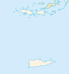
Charlotte Amalie
| Ten artykuł od 2014-04 wymaga zweryfikowania podanych informacji. |
| ||
 Widok na miasto | ||
| Państwo | ||
| Terytorium nieinkorporowane | ||
| Populacja (2000) • liczba ludności | 18 914 | |
| Nr kierunkowy | 340 | |
| Kod pocztowy | 00801–00804 | |
| Strona internetowa | ||
Charlotte Amalie – stolica i największe miasto kolonii Wyspy Dziewicze Stanów Zjednoczonych położona w południowej części wyspy Saint Thomas. Ludność: 19 000 (2004). Miasto zostało założone przez Jørgena Iversena i nazwane na cześć królowej duńskiej Charlotte Amalie (Karoliny Amelii), małżonki króla Chrystiana V.
Media użyte na tej stronie
The flag of Navassa Island is simply the United States flag. It does not have a "local" flag or "unofficial" flag; it is an uninhabited island. The version with a profile view was based on Flags of the World and as a fictional design has no status warranting a place on any Wiki. It was made up by a random person with no connection to the island, it has never flown on the island, and it has never received any sort of recognition or validation by any authority. The person quoted on that page has no authority to bestow a flag, "unofficial" or otherwise, on the island.
Autor: Autor nie został podany w rozpoznawalny automatycznie sposób. Założono, że to Juanpdp (w oparciu o szablon praw autorskich)., Licencja: CC BY-SA 2.5
w:Explorer of the Seas and w:Sea Princess at Charlotte Amalie, St. Thomas, US VI.
Photography taken by JuanPDP on 07-Oct-2005


