Chatham (Anglia)
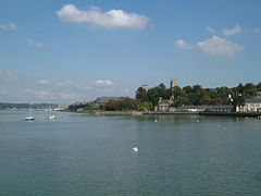
 Brzeg rzeki ze Słonecznego Molo (Sun Pier) w Chatham | |
| Państwo | |
|---|---|
| Kraj | |
| Region | South East |
| Hrabstwo | Kent |
| Populacja (2001) • liczba ludności | 70 540 |
| Nr kierunkowy | 01634 |
Położenie na mapie Kentu Contains Ordnance Survey data © Crown copyright and database right, CC BY-SA 3.0 | |
Położenie na mapie Wielkiej Brytanii (c) Karte: NordNordWest, Lizenz: Creative Commons by-sa-3.0 de | |
| Portal | |
Chatham – miasto w Wielkiej Brytanii, w Anglii, w hrabstwie Kent, przy ujściu rzeki Medway do Morza Północnego.
Historia
Nazwę Chatham zapisano po raz pierwszy jako Cetham, w roku 880. Pochodzi od rdzenia ceto i staroangielskiego ham, co w sumie oznacza osadę leśną[1][2]. W Domesday Book jej nazwę zapisano jako Ceteham.
Gospodarka
W mieście rozwinął się przemysł stoczniowy, spożywczy oraz drzewny[3].
Przypisy
Media użyte na tej stronie
(c) Karte: NordNordWest, Lizenz: Creative Commons by-sa-3.0 de
Location map of the United Kingdom
Flag of England. Saint George's cross (a red cross on a white background), used as the Flag of England, the Italian city of Genoa and various other places.
Autor: Clem Rutter, Rochester Kent stitched by Marku1988 Ta panorama została stworzona za pomocą Autostitch (Panoramy mogą różnić się od rzeczywistego widoku tego miejsca)., Licencja: CC-BY-SA-3.0
Medway Estuary at Chatham, by Sun Pier. A view of the River Medway Estuary, from Anchorage House Chatham. From Left to Right we see Limehouse Reach with Ship Pier, two trains in Rochester station, Rochester Cathedral and Castle . At Gashouse point the river veers port onto Bridge Reach. On the horizon is Strood and All Saints Frindsbury. In front is the Frindsbury Peninsula and its nearest point is Chatham Ness. Behind the lightship is Chatham Reach. On the left bank we can just see Upnor Castle, and on the horizon Chattenden. On the right bank, we see the buildings of Chatham Dockyard. Then we have Medway Council headquarters, with the flats at Melville Court behind, Chatham Parish Church, the Command House pub, sun pier with the library with Fort Amherst Caveyard behind, the Rats Bay pumping station with Upper Cornwallis battery behind.
| Pozycja fotografa |
|
To i inne zdjęcia na: OpenStreetMap |
|
|---|
Autor: Clem Rutter, Rochester Kent, Licencja: CC BY 2.5
Chatham lies on the outside arc of the tidal River Medway. Upstream is Rochester and downstream is Chatham Dockyard. Looking downstream, we see the coverslips, Anchor Wharf storehouses, then Gun Wharf with Lloyds Building- HQ of Medway Council, the high rise flats at Melville Court, the Command House pub, with St Mary's Church above, and Chatham Library with Fort Amherst above. On the far bank is Upnor Castle.
| Pozycja fotografa |
|
To i inne zdjęcia na: OpenStreetMap |
|
|---|
Contains Ordnance Survey data © Crown copyright and database right, CC BY-SA 3.0
Map of Kent, UK with the following information shown:
- Administrative borders
- Coastline, lakes and rivers
- Roads and railways
- Urban areas
Equirectangular map projection on WGS 84 datum, with N/S stretched 160%
Geographic limits:
- West: 0.01E
- East: 1.47E
- North: 51.52N
- South: 50.88N


