Chaurikharka
| gaun wikas samiti | |
 | |
| Państwo | |
|---|---|
| Strefa | Sagarmatha |
| Dystrykt | Solukhumbu |
| Populacja (2001) • liczba ludności | 3080 |
Położenie na mapie Nepalu  (c) Karte: NordNordWest, Lizenz: Creative Commons by-sa-3.0 de | |
Chaurikharka – gaun wikas samiti we wschodniej części Nepalu w strefie Sagarmatha w dystrykcie Solukhumbu[1]. Według nepalskiego spisu powszechnego z 2001 roku liczył on 690 gospodarstw domowych i 3080 mieszkańców (1504 kobiet i 1576 mężczyzn)[2].
- Chaurikharka - od Lukli do Namche
Od Lukli do Chheplung

Chheplung

Chhuthawa

Phakding

Widok na góry

Monju

Sagarmatha Park

Dudh Koshi

Most Larja

Przewoźnicy
Przypisy
- ↑ Index of Geographical names of Nepal - Eastern Development Region - Volume I (ang.). National Geographic Information Infrastructure Programme. [dostęp 2010-09-27].
- ↑ VDC’s population (ang.). National Association of Village Development Committees in Nepal (NAVIN). [dostęp 2020-10-12].
- Stolica dystryktu: Salleri
Media użyte na tej stronie

Phakding-Namche-30-Monju-Khola-Bruecke-2007-gje.jpg
Autor: Gerd Eichmann, Licencja: CC BY-SA 4.0
from Phakding to Namche
Autor: Gerd Eichmann, Licencja: CC BY-SA 4.0
from Phakding to Namche

Phakding-Namche-72-Larja-Bruecke-2007-gje.jpg
Autor: Gerd Eichmann, Licencja: CC BY-SA 4.0
from Phakding to Namche
Autor: Gerd Eichmann, Licencja: CC BY-SA 4.0
from Phakding to Namche
Kosi or Koshi River near Village Ghat Nepal.jpg
Autor: John Pavelka, Licencja: CC BY 2.0
Dudhkoshi bei Ghat (VDC Chaurikharka, Nepal), Bild von 1997, die Gebäude wurden weitgehend ersetzt
Autor: John Pavelka, Licencja: CC BY 2.0
Dudhkoshi bei Ghat (VDC Chaurikharka, Nepal), Bild von 1997, die Gebäude wurden weitgehend ersetzt

Phakding-Namche-88-Traeger-2007-gje.jpg
Autor: Gerd Eichmann, Licencja: CC BY-SA 4.0
from Phakding to Namche
Autor: Gerd Eichmann, Licencja: CC BY-SA 4.0
from Phakding to Namche
Nepal adm location map.svg
(c) Karte: NordNordWest, Lizenz: Creative Commons by-sa-3.0 de
Location map of Nepal including the 7 provinces
(c) Karte: NordNordWest, Lizenz: Creative Commons by-sa-3.0 de
Location map of Nepal including the 7 provinces

Phakding-Namche-58-Dudh Koshi-2007-gje.jpg
Autor: Gerd Eichmann, Licencja: CC BY-SA 4.0
from Phakding to Namche
Autor: Gerd Eichmann, Licencja: CC BY-SA 4.0
from Phakding to Namche

Chheplung-14-Manitafeln-2007-gje.jpg
Autor: Gerd Eichmann, Licencja: CC BY-SA 4.0
from Lukla to Phakding
Autor: Gerd Eichmann, Licencja: CC BY-SA 4.0
from Lukla to Phakding


Chhuthawa-06-Kloster-2007-gje.jpg
Autor: Gerd Eichmann, Licencja: CC BY-SA 4.0
from Lukla to Phakding
Autor: Gerd Eichmann, Licencja: CC BY-SA 4.0
from Lukla to Phakding


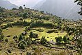
Lukla to Chheplung-12-Felder-2007-gje.jpg
Autor: Gerd Eichmann, Licencja: CC BY-SA 4.0
from Lukla to Phakding
Autor: Gerd Eichmann, Licencja: CC BY-SA 4.0
from Lukla to Phakding

Phakding-Namche-18-Landschaft-2007-gje.jpg
Autor: Gerd Eichmann, Licencja: CC BY-SA 4.0
from Phakding to Namche
Autor: Gerd Eichmann, Licencja: CC BY-SA 4.0
from Phakding to Namche

Phakding-Namche-42-Sagarmatha-Park-Eingang-2007-gje.jpg
Autor: Gerd Eichmann, Licencja: CC BY-SA 4.0
from Phakding to Namche
Autor: Gerd Eichmann, Licencja: CC BY-SA 4.0
from Phakding to Namche