Chelsham
| ||
 | ||
| Państwo | ||
| Kraj | ||
| Hrabstwo | Surrey | |
| Dystrykt | Tandridge | |
| Nr kierunkowy | 01883 | |
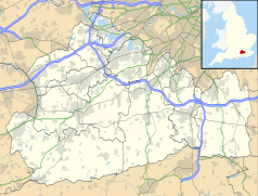
Położenie na mapie Surrey Contains Ordnance Survey data © Crown copyright and database right, CC BY-SA 3.0 | ||
Położenie na mapie Wielkiej Brytanii (c) Karte: NordNordWest, Lizenz: Creative Commons by-sa-3.0 de | ||
| Portal | ||
Chelsham – wieś w Anglii, w hrabstwie Surrey, w dystrykcie Tandridge. Leży 23 km na południe od centrum Londynu[1].
Przypisy
- ↑ Chelsham na mapie (ang.). getamap.ordnancesurvey.co.uk. [dostęp 2010-11-27].
Media użyte na tej stronie
(c) Karte: NordNordWest, Lizenz: Creative Commons by-sa-3.0 de
Location map of the United Kingdom
Flag of England. Saint George's cross (a red cross on a white background), used as the Flag of England, the Italian city of Genoa and various other places.
Autor: RHaworth, Licencja: CC-BY-SA-3.0
The water tower of Warlingham Park Hospital in what is now called Tower Place at grid reference TQ 373 595 in Chelsham, Surrey. The site is at about 180 metres above sea level on the North Downs. Water would have been obtained from a bore hole into the underlying chalk and pumped to the tank at the top of the tower. The black board had a marker on it, linked to float in the tank, which showed the depth of water - up to 21 ft.
Contains Ordnance Survey data © Crown copyright and database right, CC BY-SA 3.0
Map of Surrey, UK with the following information shown:
- Administrative borders
- Coastline, lakes and rivers
- Roads and railways
- Urban areas
Equirectangular map projection on WGS 84 datum, with N/S stretched 160%
Geographic limits:
- West: 0.87W
- East: 0.08E
- North: 51.50N
- South: 51.05N


