Chertsey
 | |
| Państwo | |
|---|---|
| Kraj | |
| Hrabstwo | |
| Dystrykt | |
| Populacja • liczba ludności |
|
| Nr kierunkowy | 01932 |
| Kod pocztowy | KT16 |
Położenie na mapie Surrey  Contains Ordnance Survey data © Crown copyright and database right, CC BY-SA 3.0 | |
Położenie na mapie Wielkiej Brytanii  (c) Karte: NordNordWest, Lizenz: Creative Commons by-sa-3.0 de | |
Położenie na mapie Anglii  | |
| Strona internetowa | |
| Portal | |
Chertsey – miasto w Anglii, w hrabstwie Surrey, w dystrykcie Runnymede. Leży 30 km na południowy zachód od centrum Londynu[2]. Miasto liczy 15 967 mieszkańców[1].
Galeria
 (c) Chertsey Bridge by Jim Osley, CC BY-SA 2.0
Most ponad Tamizą

Pieczęć opactwa
 (c) Rob Emms, CC BY-SA 2.0
Na autostradowej obwodnicy M25
 (c) Colin Smith, CC BY-SA 2.0
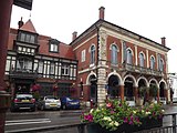
Były ratusz
Przypisy
- ↑ a b Census data. [dostęp 2010-12-20]. [zarchiwizowane z tego adresu (2013-05-22)].
- ↑ Chertsey na mapie (ang.). getamap.ordnancesurvey.co.uk. [dostęp 2010-11-27].
Kontrola autorytatywna (miasteczko):
Media użyte na tej stronie
United Kingdom adm location map.svg
(c) Karte: NordNordWest, Lizenz: Creative Commons by-sa-3.0 de
Location map of the United Kingdom
(c) Karte: NordNordWest, Lizenz: Creative Commons by-sa-3.0 de
Location map of the United Kingdom


Flag of England.svg
Flag of England. Saint George's cross (a red cross on a white background), used as the Flag of England, the Italian city of Genoa and various other places.
Flag of England. Saint George's cross (a red cross on a white background), used as the Flag of England, the Italian city of Genoa and various other places.
.png)
The Conventual Seal, Chertsey Abbey (Surrey Archaeological Collections).png
The conventual seal, Chertsey Abbey, as published in Surrey Archaeological Collections volume 1
The conventual seal, Chertsey Abbey, as published in Surrey Archaeological Collections volume 1

Motorway Gantry over M25 - geograph.org.uk - 334558.jpg
(c) Rob Emms, CC BY-SA 2.0
Motorway Gantry over M25 Junction 12 Gantry, clockwise over M25. Behind this is a railway bridge. Just visible are electricity cables crossing the motorway.
(c) Rob Emms, CC BY-SA 2.0
Motorway Gantry over M25 Junction 12 Gantry, clockwise over M25. Behind this is a railway bridge. Just visible are electricity cables crossing the motorway.
Surrey UK location map.svg
Contains Ordnance Survey data © Crown copyright and database right, CC BY-SA 3.0
Contains Ordnance Survey data © Crown copyright and database right, CC BY-SA 3.0
Map of Surrey, UK with the following information shown:
- Administrative borders
- Coastline, lakes and rivers
- Roads and railways
- Urban areas
Equirectangular map projection on WGS 84 datum, with N/S stretched 160%
Geographic limits:
- West: 0.87W
- East: 0.08E
- North: 51.50N
- South: 51.05N
.jpg)
Chertsey, Old Town Hall (geograph 3043484).jpg
(c) Colin Smith, CC BY-SA 2.0
Chertsey, Old Town Hall
(c) Colin Smith, CC BY-SA 2.0
Chertsey, Old Town Hall

Chertsey Bridge - geograph.org.uk - 3037289.jpg
(c) Chertsey Bridge by Jim Osley, CC BY-SA 2.0
Chertsey Bridge
(c) Chertsey Bridge by Jim Osley, CC BY-SA 2.0
Chertsey Bridge
Chertrsey Road2.jpg
Autor: Christianmesmar, Licencja: CC BY-SA 3.0
Pyrcroft rd., Chertsey. Next to Phoenix Plaza
Autor: Christianmesmar, Licencja: CC BY-SA 3.0
Pyrcroft rd., Chertsey. Next to Phoenix Plaza