Cheshire
| Hrabstwo ceremonialne | |||||
 Krajobraz hrabstwa Cheshire | |||||
| |||||
| Państwo | |||||
|---|---|---|---|---|---|
| Kraj | |||||
| Region | |||||
| Siedziba | |||||
| Powierzchnia | 2343 km² | ||||
| Populacja (2011) • liczba ludności |
| ||||
| • gęstość | 438,6 os./km² | ||||
| Szczegółowy podział administracyjny | |||||
(c) Dpaajones, CC BY-SA 3.0 | |||||
| Liczba unitary authorities | 4 | ||||
Położenie na mapie | |||||
| Portal | |||||
Cheshire (wymowa: [ˈt͡ʃɛʃə]) – hrabstwo ceremonialne i historyczne w zachodniej Anglii, w regionie North West England, położone nad estuariami rzek Mersey i Dee, przy granicy z Walią. Do 2009 roku pełniło funkcję administracyjną jako hrabstwo niemetropolitalne.
Cheshire liczy 2343 km² powierzchni, a liczba mieszkańców hrabstwa wynosi 1 027 700 (2011)[1]. Dawnym ośrodkiem administracyjnym, a zarazem jedynym miastem posiadającym status city, jest Chester, położony na zachodzie hrabstwa.
Największym miastem na terenie hrabstwa jest Warrington. Innymi większymi miastami w Cheshire są Chester, Crewe, Ellesmere Port, Runcorn, Widnes i Macclesfield[2]. Północna część hrabstwa, położona nad rzeką Mersey, w zasięgu aglomeracji Liverpoolu i Manchesteru, charakteryzuje się wyższym stopniem urbanizacji niż południowa, która w znaczej części ma charakter wiejski.
Na północnym zachodzie Cheshire graniczy z hrabstwem Merseyside, na północnym wschodzie z Wielkim Manchesterem, na wschodzie z Derbyshire, na południowym wschodzie ze Staffordshire, na południowym zachodzie ze Shropshire, a na zachodzie z walijskimi hrabstwami Wrexham i Flintshire.
Podział administracyjny
Obecny
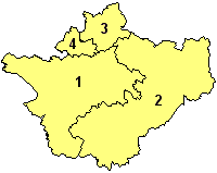
W skład hrabstwa ceremonialnego wchodzą cztery jednostki administracyjne typu unitary authority:
Do 2009
Przed reformą administracyjną przeprowadzoną w 2009 roku Cheshire było hrabstwem niemetropolitalnym, w którego skład wchodziło sześć dystryktów. Jako hrabstwo ceremonialne Cheshire obejmowało dodatkowo dwie jednostki typu unitary authority.
- Ellesmere Port and Neston
- Chester
- Crewe and Nantwich
- Congleton
- Macclesfield
- Vale Royal
- Halton (unitary authority)
- Warrington (unitary authority)
W kulturze
Hrabstwo Cheshire jest miejscem pochodzenia Kota z Cheshire, bohatera powieści Alicja w Krainie Czarów, które autorem jest Lewis Carroll[3]
Mapa
Uwagi
- ↑ Do czasu pozbawienia hrabstwa funkcji administracyjnej w 2009 roku.
Przypisy
- ↑ Table P04 2011 Census: Usual resident population by five-year age group, local authorities in England and Wales. Office for National Statistics. [dostęp 2012-07-18]. (ang.).
- ↑ a b Office for National Statistics: KS101EW - Usual resident population. [w:] 2011 Census [on-line]. Nomis – Official labour market statistics, 2013-02-12. [dostęp 2022-06-05]. (ang.).
- ↑ Carroll Lewis, Alicja w Krainie Czarów, tłum. Maciej Stomczyński, 1965
- ↑ Office for National Statistics: Built-up Area to Local Authority District (December 2011) Lookup in England and Wales. [w:] Open Geography Portal [on-line]. [dostęp 2022-06-05]. (ang.).
- ↑ Office for National Statistics: Built-up Area Sub Divisions (December 2011) Boundaries. [w:] Open Geography Potal [on-line]. [dostęp 2022-06-05]. (ang.).
Bibliografia
- Cheshire, [w:] Encyclopædia Britannica [online] [dostęp 2011-11-01] (ang.).
Media użyte na tej stronie
Flag of England. Saint George's cross (a red cross on a white background), used as the Flag of England, the Italian city of Genoa and various other places.
Contains Ordnance Survey data © Crown copyright and database right, CC BY-SA 3.0
Map of Cheshire, UK with the following information shown:
- Administrative borders
- Coastline, lakes and rivers
- Roads and railways
- Urban areas
Equirectangular map projection on WGS 84 datum, with N/S stretched 165%
Geographic limits:
- West: 3.15W
- East: 1.95W
- North: 53.50N
- South: 52.94N
Autor: Kentynet, Licencja: CC BY-SA 3.0
The view from the summit of Bosley Cloud looking north over Cheshire East.
Autor:
Praca własna (with reference to this and this)
, Licencja: CC BY-SA 3.0The County Flag of Cheshire, comprising a banner of arms of the former Cheshire County Council.
The Arms of Cheshire County Council
(c) Dpaajones, CC BY-SA 3.0
Cheshire ceremonial county with unitary authorities from 2009.
- 1 = Cheshire West and Chester (new)
- 2 = Cheshire East (new)
- 3 = Warrington (existing)
- 4 = Halton (existing)
Autor: Nilfanion, Licencja: CC BY-SA 3.0
Location of the ceremonial county of Cheshire within England.


