Cheyenne (rzeka)
 | |
| Kontynent | |
|---|---|
| Państwo | |
| Rzeka | |
| Długość | 848[1] km |
| Powierzchnia zlewni | 64 700 km² |
| Średni przepływ | 414[2] m³/s |
| Źródło | |
| Miejsce | Góry Skaliste, Fiddleback Ranch[1] |
| Współrzędne | |
| Ujście | |
| Recypient | |
| Miejsce | Sansarc |
| Wysokość | 480 |
| Współrzędne | |
Cheyenne River – rzeka w środkowo-zachodniej części USA (stany Wyoming i Dakota Południowa[3]) o długości 848 km oraz powierzchni dorzecza 64 700 km².
Rzeka ta wypływa ze wschodnich stoków Gór Skalistych, a uchodzi do Missouri (prawy dopływ).
Główny dopływ rzeki to Belle Fourche River.
Woda z Cheyenne River jest pozyskiwana do nawadniania. W środkowym biegu rzeki znajduje się zapora wodna oraz zbiornik retencyjny Angostura.
Przypisy
- ↑ a b c Feature Detail Report for: Cheyenne River. The Geographic Names Information System (GNIS). [dostęp 2018-06-21]. (ang.).
- ↑ USGS 06386500 Cheyenne River near Spencer, WY. U.S. Geological Survey. [dostęp 2018-06-21]. (ang.).
- ↑ Cheyenne, [w:] Encyklopedia PWN [online] [dostęp 2022-12-22].
Media użyte na tej stronie
Autor: Uwe Dedering, Licencja: CC BY-SA 3.0
Relief location map of the USA (without Hawaii and Alaska).
EquiDistantConicProjection : Central parallel :
* N: 37.0° N
Central meridian :
* E: 96.0° W
Standard parallels:
* 1: 32.0° N
* 2: 42.0° N
Made with Natural Earth. Free vector and raster map data @ naturalearthdata.com.
Formulas for x and y:
x = 50.0 + 124.03149777329222 * ((1.9694462586094064-({{{2}}}* pi / 180))
      * sin(0.6010514667026994 * ({{{3}}} + 96) * pi / 180))
y = 50.0 + 1.6155950752393982 * 124.03149777329222 * 0.02613325650382181
      - 1.6155950752393982  * 124.03149777329222 *
     (1.3236744353715044  - (1.9694462586094064-({{{2}}}* pi / 180))
      * cos(0.6010514667026994 * ({{{3}}} + 96) * pi / 180))
The flag of Navassa Island is simply the United States flag. It does not have a "local" flag or "unofficial" flag; it is an uninhabited island. The version with a profile view was based on Flags of the World and as a fictional design has no status warranting a place on any Wiki. It was made up by a random person with no connection to the island, it has never flown on the island, and it has never received any sort of recognition or validation by any authority. The person quoted on that page has no authority to bestow a flag, "unofficial" or otherwise, on the island.
Autor: Jeffrey Beall, Licencja: CC BY-SA 3.0
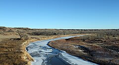
The Cheyenne River. The view is looking northwards, and the picture was taken from a car traveling on Interstate-90.


