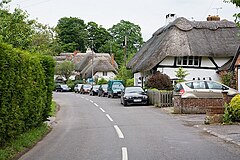
Chilbolton
| ||
(c) Peter Facey, CC BY-SA 2.0 | ||
| Państwo | ||
| Kraj | ||
| Hrabstwo | Hampshire | |
| Dystrykt | Test Valley | |
| Populacja (2001) • liczba ludności | 1010[1] | |
| Nr kierunkowy | 01264 | |
| Kod pocztowy | SO20 | |
Położenie na mapie Hampshire Contains Ordnance Survey data © Crown copyright and database right, CC BY-SA 3.0 | ||
Położenie na mapie Wielkiej Brytanii (c) Karte: NordNordWest, Lizenz: Creative Commons by-sa-3.0 de | ||
| Portal | ||
Chilbolton – wieś w Anglii, w hrabstwie Hampshire, w dystrykcie Test Valley. Leży 12 km na północ od miasta Winchester i 100 km na południowy zachód od Londynu[2]. W 2001 miejscowość liczyła 1010 mieszkańców[1].
We wsi mieści się byłe lotnisko wojskowe RAF Chilbolton, z czasów II wojny światowej, używane w latach 1940-1946. Po wojnie testowano tam m.in. odrzutowe myśliwce firmy Supermarine[3]: Supermarine Attacker, Supermarine Swift, Supermarine Scimitar. Obecnie częściowo zajęte jest przez obserwatorium meteorologiczne Chilbolton Observatory.
- (c) Andrew Smith, CC BY-SA 2.0
Radioteleskop w Chilbolton
Przypisy
- ↑ a b Parish Headcounts, Area: Chilbolton CP. W: Neighbourhood Statistics [on-line]. Office for National Statistics, 2001. [dostęp 2008-02-27].
- ↑ Chilbolton na mapie (ang.). getamap.ordnancesurvey.co.uk. [dostęp 2010-10-06].
- ↑ Tony Buttler: Supermarine Swift and Type 535. Hall Park Books, s. 5-7, seria: Warpaint Series. No.58. (ang.)
Media użyte na tej stronie
(c) Karte: NordNordWest, Lizenz: Creative Commons by-sa-3.0 de
Location map of the United Kingdom
Flag of England. Saint George's cross (a red cross on a white background), used as the Flag of England, the Italian city of Genoa and various other places.
Contains Ordnance Survey data © Crown copyright and database right, CC BY-SA 3.0
Map of Hampshire, UK with the following information shown:
- Administrative borders
- Coastline, lakes and rivers
- Roads and railways
- Urban areas
Equirectangular map projection on WGS 84 datum, with N/S stretched 155%
Geographic limits:
- West: 2.01W
- East: 0.68W
- North: 51.41N
- South: 50.68N
442d Troop Carrier Group at Chilbolton airfield just before Operation Market Garden.
(c) Andrew Smith, CC BY-SA 2.0
Radio telescope, Chilbolton The proximity of the nearer dish may make it look misleadingly large. For the Wikipedia article on the observatory see Chilbolton_Observatory .
(c) Peter Facey, CC BY-SA 2.0
Village Street, Chilbolton Approaching the eastern end of Chilbolton on what is the principal road through the village.


