Chinatown (Los Angeles)
| dzielnica Los Angeles | |
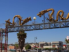
 Oficjalne wejście do Chinatown | |
| Państwo | |
|---|---|
| Stan | |
| Miasto | Los Angeles |
| Dzielnica | Downtown Los Angeles |
| Powierzchnia | 2,3 km² |
| Populacja (2010) • liczba ludności | 28.939 |
| • gęstość | 12582 os./km² |
| Kod pocztowy | 90012 |
| Portal | |
Chinatown – dzielnica w śródmieściu (downtown) Los Angeles w Kalifornii w USA. Jest jedną z kilkunastu chińskich dzielnic w Kalifornii. Centrum kulturalno-społeczne ludności pochodzenia chińskiego w południowej Kalifornii i atrakcja turystyczna miasta. Chinatown ma niskie dochody, a liczba mieszkańców wynosi około 10.000.

Historia
Pierwotnie Chinatown została założona pod koniec dziewiętnastego wieku, lecz rozebrano ją, aby uczynić miejsce dla Union Station, które jest głównym centrum komunikacyjnym w mieście[1][2]. Oddzielny ośrodek handlu, znany jako New Chinatown, został utworzony w roku 1938. W tym rejonie znajdują się dwie szkoły, oddział biblioteczny, park a również centrum medyczne/szpital.
Filmografia
Nazwa dzielnicy jest tytułem filmu Romana Polańskiego Chinatown z 1974 roku[3]. Film ten został częściowo nakręcony na ulicy Spring Street w Chinatown. Zdjęcia do filmu "Godziny szczytu" zostały zrobione w tej dzielnicy[4]. Plenery Chinatown są często wykorzystywane w różnych produkcjach filmowych i telewizyjnych.
Filmy fabularne
Zobacz też
Przypisy
- ↑ Angels Walk–Union Station/El Pueblo/Little Tokyo/Center, published by Angels Walk LA, 2000
- ↑ Chinatown Los Angeles California, Restaurants in Chinatown, Pictures of Chinatown
- ↑ a b Film locations for Chinatown (1974), www.movie-locations.com [dostęp 2017-11-22] [zarchiwizowane z adresu 2013-09-18].
- ↑ a b Historic Los Angeles Chinatown Day Trip Fun Things To Do, www.daytrippen.com [dostęp 2017-11-22] (ang.).
- ↑ 'Gangster Squad' adds to L.A.'s Chinatown credits - latimes, articles.latimes.com [dostęp 2017-11-22] (ang.).
- ↑ Filming Locations of I Love You Man - part 2, www.seeing-stars.com [dostęp 2017-11-22].
Linki zewnętrzne
Media użyte na tej stronie
Autor: Uwe Dedering, Licencja: CC BY-SA 3.0
Location map of the USA (without Hawaii and Alaska).
EquiDistantConicProjection:
Central parallel:
* N: 37.0° N
Central meridian:
* E: 96.0° W
Standard parallels:
* 1: 32.0° N
* 2: 42.0° N
Made with Natural Earth. Free vector and raster map data @ naturalearthdata.com.
Formulas for x and y:
x = 50.0 + 124.03149777329222 * ((1.9694462586094064-({{{2}}}* pi / 180))
      * sin(0.6010514667026994 * ({{{3}}} + 96) * pi / 180))
y = 50.0 + 1.6155950752393982 * 124.03149777329222 * 0.02613325650382181
      - 1.6155950752393982  * 124.03149777329222 *
     (1.3236744353715044  - (1.9694462586094064-({{{2}}}* pi / 180))
      * cos(0.6010514667026994 * ({{{3}}} + 96) * pi / 180))
Autor: NordNordWest, Licencja: CC BY 3.0
Location map of California, USA
The flag of Navassa Island is simply the United States flag. It does not have a "local" flag or "unofficial" flag; it is an uninhabited island. The version with a profile view was based on Flags of the World and as a fictional design has no status warranting a place on any Wiki. It was made up by a random person with no connection to the island, it has never flown on the island, and it has never received any sort of recognition or validation by any authority. The person quoted on that page has no authority to bestow a flag, "unofficial" or otherwise, on the island.
Flag of California. This version is designed to accurately depict the standard print of the bear as well as adhere to the official flag code regarding the size, position and proportion of the bear, the colors of the flag, and the position and size of the star.
Autor: Alexrk2, Licencja: CC BY 3.0
Ta mapa została stworzona za pomocą GeoTools.
Autor: Brion VIBBER, Licencja: CC-BY-SA-3.0
West facade of the Los Angeles City Hall — in Downtown Los Angeles, California.
- In process of seismic upgrading, this 1928 high-rise building was placed atop a mechanical system of isolators, sliders, and dampers called "base isolation technology".
- It is the tallest base-isolated structure in the world.
Autor: Buchanan-Hermit, Licencja: Attribution
A view of the Los Angeles Chinatown. Los Angeles, CA, USA.
Los Angeles Chinatown. Taken from http://www.pdphoto.org/PictureDetail.php?mat=pdef&pg=8156 , according to http://www.pdphoto.org/index.php, this image is public domain
An approximation of the seal of Los Angeles, California. On March 27, 1905 Ordinance 10,834 authorized and described the City Seal still being used today.[1].


