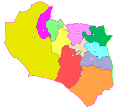
Chorasan Południowy
| ostan | |
 Podział administracyjny Chorasanu Południowego | |
| Państwo | |
|---|---|
| Siedziba | |
| Powierzchnia | 95 385 km²[1] |
| Populacja (2011) • liczba ludności |
|
| • gęstość | 7 os./km²[1] |
Położenie na mapie Iranu | |
Chorasan Południowy – ostan we wschodnim Iranie. Stolicą jest Birdżand. Drugim znaczącym miastem jest Ferdous.
- powierzchnia: 95 385 km²
- ludność: 662 534 (spis 2011)
W 2018 roku oddano do użytku pierwszą elektrownię fotowoltaiczną o mocy 10MW. Jej koszt to 14 mln USD. Jest ona położona w mieście Khusf.
Przypisy
- ↑ a b c National Population and Housing Census 2011 (ang.). The President’s Office Deputy of Strategic Planning and Control, Statistical Center of Iran, 2011. [dostęp 2016-06-20].
Media użyte na tej stronie
State emblem of the Islamic Republic of Iran. U+262B, stylized version of Arabic script of Allah (الله, with the central lam shaped to look like a sword.) The emblem is also an overlaid rendering of La Ilaha Illa Allah (There is only one God and that is 'Allah'). The exact shape of the emblem and an algorithmic ruler-and-compass construction is described in the national Iranian standard at IRANIAN ISLAMIC REPUBLIC FLAG, ISIRI 1, 1371, 3rd edition, March 1993 in Persian. The emblem was designed by Hamid Nadimi, and was officially approved by Ayatollah Khomeini on May 9, 1980.
State emblem of the Islamic Republic of Iran. U+262B, stylized version of Arabic script of Allah (الله, with the central lam shaped to look like a sword.) The emblem is also an overlaid rendering of La Ilaha Illa Allah (There is only one God and that is 'Allah'). The exact shape of the emblem and an algorithmic ruler-and-compass construction is described in the national Iranian standard at IRANIAN ISLAMIC REPUBLIC FLAG, ISIRI 1, 1371, 3rd edition, March 1993 in Persian. The emblem was designed by Hamid Nadimi, and was officially approved by Ayatollah Khomeini on May 9, 1980.
Autor: M samadi, Licencja: CC BY-SA 3.0
Map of South Khorasan Province with its counties.
Autor: Original work by Uwe Dering. Highlighted by Dr. Blofeld, Licencja: CC BY-SA 3.0
Locator map of Iran


