Cieśnina Bougainville’a

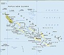
Cieśnina Bougainville’a – cieśnina oddzielająca wyspy Choiseul i Bougainville’a. Po raz pierwszy przepłynął przez nią Louis Antoine de Bougainville w 1768 roku. W 1788 roku przepłynął przez nią porucznik Royal Navy John Shortland, nadając kilku wyspom leżącym w cieśninie nazwę Treasury Islands[1]. Shortland nazwał cieśninę swoim nazwiskiem, lecz później stała się znana jako Cieśnina Bougainville’a[2]
Cieśnina Bougainville’a jest częścią trasy statków transportowych płynących z Cieśniny Torresa do Kanału Panamskiego. Jest to jedna z trzech tras statków handlowych przez Wyspy Salomona; trasy biegną przez Cieśninę Bougainville’a i Indispensable, które łączą Pacyfik, Morze Salomona i Morze Koralowe; i przez Cieśninę Manning, która łączy Pacyfik z Cieśniną Nowej Georgii (ang. New Georgia Sound), znaną również jako The Slot, przez którą Japończycy transportowali uzupełnienia dla garnizonu na Guadalcanalu podczas II wojny światowej[3]
Przypisy
- ↑ Alexander George Findlay: A directory for the navigation of the Pacific ocean. R. H. Laurie, 1851, s. 1012.
- ↑ Gordon L. Rottman: World War II Pacific Island Guide. Greenwood Publishing Group, 2002, s. 101. ISBN 978-0-313-31395-0.
- ↑ Josef Rick, Rüdiger Wolfrum, Ursula E. Heinz, Denise A. Bizzarro: Title Law of the sea at the crossroads. Duncker & Humblot, 1991, s. 115. ISBN 978-3-428-47240-6.
Linki zewnętrzne
- Mapa cieśniny. encarta.msn.com. [zarchiwizowane z tego adresu (2009-10-28)].
Media użyte na tej stronie
Solomon Islands map, modified and cropped from PCL map collection Courtesy of the University of Texas Libraries, The University of Texas at Austin.
According to the University of Texas, "most of the maps scanned by the University of Texas Libraries and served from this web site are in the public domain. No permissions are needed to copy them. You may download them and use them as you wish. A few maps are copyrighted, and are clearly marked as such.". As the image, when downloaded from here was no tagged, the map is PD.
For a small map of the Solomon Islands, see: Image:SolomonIslandsMap.png
Note that provincial borders are pre-1995; Rennell and Bellona has separated from Central Province, and Choiseul Province has separated from Western Province.
Originally uploaded to En-Wikipedia by Darwinek on 13:39, 29 December 2004.