Cieśnina Unimak
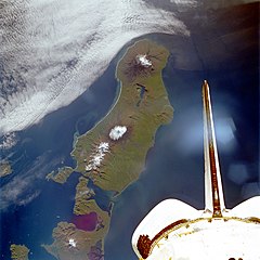
 W górnej części zdjęcia powyżej wyspy Unimak widoczna cieśnina Unimak częściowo przysłonięta smugą chmur | |
| Państwo | |
|---|---|
| Stan | |
Cieśnina Unimak (ang. Unimak Pass lub Unimak Passage[1], ros. Пролив Унимак) – cieśnina na południowy zachód od wyspy Unimak w środkowej części archipelagu Aleutów. Łączy Morze Beringa z Oceanem Spokojnym.
Jej rozmiary: szerokość 19,6 km, głębokość 72 m, powierzchnia przekroju 1,18 km ². Wartości zasolenia wód - 32,0 ‰. W Cieśninie temperatura wody nie spada poniżej 3,5 °C.[2]
Przypisy
- ↑ PODZIAŁ OCEANU ŚWIATOWEGO - ocean.am.gdynia.pl
- ↑ Пролив Унимак (Cieśnina Unimak) - www.pacificinfo.ru (ros.). [dostęp 2014-05-02]. [zarchiwizowane z tego adresu (2008-03-28)].
Media użyte na tej stronie
The flag of Navassa Island is simply the United States flag. It does not have a "local" flag or "unofficial" flag; it is an uninhabited island. The version with a profile view was based on Flags of the World and as a fictional design has no status warranting a place on any Wiki. It was made up by a random person with no connection to the island, it has never flown on the island, and it has never received any sort of recognition or validation by any authority. The person quoted on that page has no authority to bestow a flag, "unofficial" or otherwise, on the island.
Unimak Island, Alaska, United States - September 1992
Seen in this southwest-looking, low-oblique photograph is Unimak Island, Alaska, the largest island in the Aleutian chain. The major volcano on the island (snow-capped peak at the center of the photograph), Shishaldin, rises approximately 9400 feet (2860 meters) and has been active during the last 175 years, with several eruptions occurring recently. The volcano is known locally as "Smoking Moses." At the southwestern end of the island is the snow-capped Pogromni Volcano. The blue lake situated in a large volcanic caldera, which can be seen midway between the Pogromni and Shishaldin volcanoes, is the result of a now extinct volcano that collapsed.
Autor: Alexrk2, Licencja: CC BY 3.0
Location map of Alaska, USA
Equirectangular projection, N/S stretching 210.0 %. Geographic limits of the map:
- N: 72.0° N
- S: 51.0° N
- W: 172.0° E
- E: 129.0° W
Autor: Uwe Dedering, Licencja: CC BY-SA 3.0
Location map of North America with national borders.
- Projection: Lambert azimuthal equal-area projection.
- Area of interest:
- N: 90.0° N
- S: 5.0° N
- W: -140.0° E
- E: -60.0° E
- Projection center:
- NS: 47.5° N
- WE: -100.0° E
- GMT projection: -JA-100/47.5/20.0c
- GMT region: -R-138.3726888474925/-3.941007863604182/2.441656573833029/50.63933645705661r
- GMT region for grdcut: -R-220.0/-4.0/20.0/90.0r
- Made with Natural Earth. Free vector and raster map data @ naturalearthdata.com.


