Cinderford
(c) Pauline Eccles, CC BY-SA 2.0 | |
| Państwo | |
|---|---|
| Kraj | |
| Hrabstwo | |
| Populacja (2001) • liczba ludności |
|
| Nr kierunkowy | 01594 |
| Kod pocztowy | GL14 |
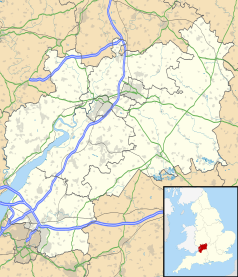
Położenie na mapie Gloucestershire Contains Ordnance Survey data © Crown copyright and database right, CC BY-SA 3.0 | |
Położenie na mapie Wielkiej Brytanii (c) Karte: NordNordWest, Lizenz: Creative Commons by-sa-3.0 de | |
| Portal | |
Cinderford - miasto w Wielkiej Brytanii, w Anglii, w regionie South West England, w hrabstwie Gloucestershire. W 2001 r. miasto to zamieszkiwało 8 116 osób.
W tym mieście ma swą siedzibę klub piłkarski - Cinderford Town F.C. oraz klub rugby - Cinderford R.F.C.
Media użyte na tej stronie
(c) Karte: NordNordWest, Lizenz: Creative Commons by-sa-3.0 de
Location map of the United Kingdom
Flag of England. Saint George's cross (a red cross on a white background), used as the Flag of England, the Italian city of Genoa and various other places.
Contains Ordnance Survey data © Crown copyright and database right, CC BY-SA 3.0
Map of Gloucestershire, UK with the following information shown:
- Administrative borders
- Coastline, lakes and rivers
- Roads and railways
- Urban areas
Equirectangular map projection on WGS 84 datum, with N/S stretched 160%
Geographic limits:
- West: 2.70W
- East: 1.60W
- North: 52.16N
- South: 51.36N
(c) Pauline Eccles, CC BY-SA 2.0
Miners' Tribute by Antony Dufort In the area of Cinderford known as The Triangle is Dufort's superb sculpture. Coal mining was one of the area's main industries until the last of five large mines closed in 1965. Mining is still undertaken at a few small mines operated by Freeminers. The centuries old mining rights which applied to iron ore, coal and other minerals and even quarrying for stone, entitle any male born within the hundred of St Briavels, aged 21 or more and who has worked for a year and a day in a mine to legally register as a Freeminer.


