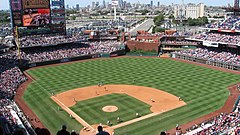
Citizens Bank Park
 | |
| Państwo | |
|---|---|
| Miejscowość | |
| Adres | 1 Citizens Bank Way, Philadelphia, PA 19148 |
| Koszt budowy | 458 milionów dolarów |
| Data budowy | 2002–2004 |
| Data otwarcia | 3 kwietnia 2004 |
| Klub | Philadelphia Phillies (2004–) |
| Pojemność stadionu | 43 647 |
Citizens Bank Park – stadion baseballowy w Filadelfii, na którym swoje mecze rozgrywa zespół Philadelphia Phillies.
Budowę obiektu rozpoczęto w czerwcu 2002, a pierwszy mecz odbył się 3 kwietnia 2004, gdy Philadelphia Phillies podejmowali Cincinnati Reds[1][2]. Obiekt posiada 43 647 miejsc[1]. Rekordową frekwencję zanotowano 2 stycznia 2012 podczas meczu rozegranego w ramach NHL Winter Classic pomiędzy Philadelphia Flyers a New York Rangers. Spotkanie obejrzało 46 967 widzów[2][3].
Na obiekcie miały miejsce również koncerty, między innymi Bon Jovi, The Police, Billy’ego Joela, Eltona Johna, Rogera Waters, Bruce’a Springsteena oraz Paula McCartneya[4].
Przypisy
- ↑ a b Citizens Bank Park (ang.). ballparksofbaseball.com. [dostęp 2017-03-05].
- ↑ a b Citizens Bank Park Philadelphia Phillies (ang.). sportsinformationtraders.com. [dostęp 2017-03-05].
- ↑ Rupp's pair helps Rangers edge Flyers (ang.). nhl.com. [dostęp 2017-03-05].
- ↑ Citizens Bank Park Philadelphia Gigography, Concert History, Past Events (ang.). songkick.com. [dostęp 2017-03-03].
Media użyte na tej stronie
Autor: Uwe Dedering, Licencja: CC BY-SA 3.0
Location map of the USA (without Hawaii and Alaska).
EquiDistantConicProjection:
Central parallel:
* N: 37.0° N
Central meridian:
* E: 96.0° W
Standard parallels:
* 1: 32.0° N
* 2: 42.0° N
Made with Natural Earth. Free vector and raster map data @ naturalearthdata.com.
Formulas for x and y:
x = 50.0 + 124.03149777329222 * ((1.9694462586094064-({{{2}}}* pi / 180))
      * sin(0.6010514667026994 * ({{{3}}} + 96) * pi / 180))
y = 50.0 + 1.6155950752393982 * 124.03149777329222 * 0.02613325650382181
      - 1.6155950752393982  * 124.03149777329222 *
     (1.3236744353715044  - (1.9694462586094064-({{{2}}}* pi / 180))
      * cos(0.6010514667026994 * ({{{3}}} + 96) * pi / 180))
The flag of Navassa Island is simply the United States flag. It does not have a "local" flag or "unofficial" flag; it is an uninhabited island. The version with a profile view was based on Flags of the World and as a fictional design has no status warranting a place on any Wiki. It was made up by a random person with no connection to the island, it has never flown on the island, and it has never received any sort of recognition or validation by any authority. The person quoted on that page has no authority to bestow a flag, "unofficial" or otherwise, on the island.
Autor:
- Gfi-set01-stadium.png: gfi
- derivative work: Frédéric (talk)
icone pour terrain de sport
Autor:
Field view from the 300 level
03:28, 11 March 2007 . . Phillyfan0419 . . 2592×1456 (1,596,180 bytes)
Autor: Alexrk2, Licencja: CC BY 3.0
Location map of Pennsylvania, USA


