City of Manchester Stadium
 | |
| Przydomek: Eastlands, COMS | |
| Państwo | |
|---|---|
| Kraj | |
| Adres | Sportcity, Rowsley St, Manchester M11 3FF |
| Koszt budowy | 110 milionów funtów |
| Data budowy | 2002 |
| Klub | |
| Inauguracja | 25 lipca 2002 (lekkoatletyka) |
| Pojemność stadionu | 55 097[1] |
| Rekordowa frekwencja | 54 693 |
| Oświetlenie | Lux 60000v |
| Wymiary boiska | 105 x 68 m |
| Nawierzchnia boiska | trawa |
Położenie na mapie Manchesteru .svg "Mapa lokalizacyjna Manchesteru") Contains Ordnance Survey data © Crown copyright and database right, CC BY-SA 3.0 | |
Położenie na mapie Wielkiej Brytanii  (c) Karte: NordNordWest, Lizenz: Creative Commons by-sa-3.0 de | |
Położenie na mapie Anglii  | |
Położenie na mapie Wielkiego Manchesteru  Contains Ordnance Survey data © Crown copyright and database right, CC BY-SA 3.0 | |
| Strona internetowa | |
City of Manchester Stadium, znany również jako CoMS lub Eastlands[3][4]; od 8 lipca 2011 roku nosi nazwę Etihad Stadium[5] – stadion w Manchesterze, Wielka Brytania. Obiekt zaprojektowany został na Igrzyska Olimpijskie w 2000 roku. Manchester nie został jednak organizatorem tej imprezy. Stadion wybudowano więc na Igrzyska Wspólnoty Narodów 2002 i kosztował on 110 milionów funtów. Następnie obiekt przekształcono do użytku piłkarskiego i w 2003 roku stał się stadionem Manchesteru City. Umowa obowiązuje na 250 lat[6].
W sezonie 2007/2008 odbył się tu finał Pucharu UEFA.
Galeria

Finał Pucharu UEFA w 2008
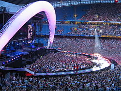
Widok podczas rockowego koncertu. Po przebudowie stadion posiada 3 rzędy trybun
 (c) Bill Boaden, CC BY-SA 2.0
Główne wejście. Widok fasady obiektu

Droga na stadion nazwana na cześć Joe Mercera
Przypisy
- ↑ Premier League Handbook Season 2015/16 (ang.). premierleague.com. [dostęp 2015-08-16]. [zarchiwizowane z tego adresu (6 września 2015)].
- ↑ Man City 1 3 Leicester (ang.). bbc.com. [dostęp 2016-02-06].
- ↑ COMS return for Bon Jovi (ang.). CityLife, 19.06.2008. [dostęp 2009-08-22].
- ↑ Rossoneri set for Eastlands (ang.). Manchester Evening News, 21.06.2008. [dostęp 2009-08-22].
- ↑ City and Etihad announce 10 year partnership (ang.). Manchester City FC, 8 lipca 2011. [dostęp 2011-07-30].
- ↑ Why Blues must cash in on name game (ang.). Manchester Evening News, 08.11.2006. [dostęp 2009-08-22].
Linki zewnętrzne
- The Stadium Guide (ang.)
![]()
![]()
Media użyte na tej stronie
(c) Karte: NordNordWest, Lizenz: Creative Commons by-sa-3.0 de
Location map of the United Kingdom


Flag of England. Saint George's cross (a red cross on a white background), used as the Flag of England, the Italian city of Genoa and various other places.

Autor:
- Gfi-set01-stadium.png: gfi
- derivative work: Frédéric (talk)
icone pour terrain de sport
Contains Ordnance Survey data © Crown copyright and database right, CC BY-SA 3.0
Map of Manchester, Greater Manchester, UK with electoral wards shown.
Equirectangular map projection on WGS 84 datum, with N/S stretched 165%
Geographic limits:
- West: 2.33W
- East: 2.13W
- North: 53.55N
- South: 53.33N

Autor: George Groutas from Idalion, Cyprus, Licencja: CC BY 2.0
Uefa Cup Final 2008
Contains Ordnance Survey data © Crown copyright and database right, CC BY-SA 3.0
Map of Greater Manchester, UK with the following information shown:
- Administrative borders
- Coastline, lakes and rivers
- Roads and railways
- Urban areas
The data includes both primary routes and railway lines.
Equirectangular map projection on WGS 84 datum, with N/S stretched 165%
Geographic limits:
- West: 2.80W
- East: 1.90W
- North: 53.70N
- South: 53.32N

.png)
Autor:
- UEFA_-_UEFA_Cup.svg: Original work by Riccardo de conciliis at it.wikipedia. SVG version by LonEMedia.
- derivative work: Ottobdn (talk)
UEFA Cup Trophy

uefa europa logo

(c) LiamUK z angielskiej Wikipedii, CC BY-SA 3.0
The City of Manchester Stadium stands, at a friendly game between Celtic F.C. and Manchester City F.C..

(c) Bill Boaden, CC BY-SA 2.0
City of Manchester Stadium This is the players' entrance, where fans naturally gather before a match.

Autor: Paul Albertella from Manchester, UK, Licencja: CC BY 2.0
The strange blue bridge from the car parks to Sportcity and the Man City stadium.
In case you were wondering, I was visiting for the City of Manchester 10K