City of Marion
| obszar samorządu lokalnego | |
Ulica English Avenue w Clovelly Park, w granicach City of Marion | |
| Państwo | |
|---|---|
| Stan | |
| Powierzchnia | 55,5 km² |
| Populacja (2007) • liczba ludności | 82229 |
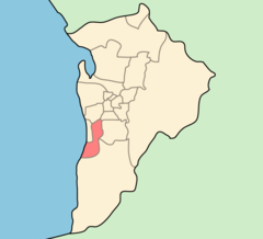
Położenie na mapie Adelaide | |
| Strona internetowa | |
| Portal | |
City of Marion – jednostka samorządowa wchodząca w skład aglomeracji Adelaide. Rada Miejska ma swoją siedzibę w dzielnicy Sturt. Marion zamieszkuje 82229 osób (dane z 2007[1]), powierzchnia wynosi 55.5 km².
Dzielnice
W nawiasach podany jest kod pocztowy.
- Ascot Park (5043)
- Clovelly Park (5042)
- Darlington (5047)
- Dover Gardens (5048)
- Edwardstown (5039)
- Glandore (5037)
- Glengowrie (5044)
- Hallett Cove (5158)
- Marino (5049)
- Marion (5043)
- Mitchell Park (5043)
- Morphettville (5043)
- O'Halloran Hill (5158)
- Oaklands Park (5046)
- Park Holme (5043)
- Plympton Park (5038)
- Seacliff Park (5049)
- Seacombe Gardens (5047)
- Seacombe Heights (5047)
- Seaview Downs (5049)
- Sheidow Park (5158)
- South Plympton (5038)
- Sturt (5047)
- Trott Park (5158)
- Warradale (5046)
Zobacz też
- Podział aglomeracji Adelaide
Przypisy
Media użyte na tej stronie
Autor: User:Martyman, Licencja: CC-BY-SA-3.0
Locator Map for Adelaide-LGA-Marion-MJC.png
Drawn by me in Illustrator and released under the GFDLCoat of arms of the city of Adelaide, in Australia
(c) Bilby at en.wikipedia, CC BY 3.0
Streetscape of English Avenue in Clovelly Park, looking east towards South Road
Clovelly Park, South Australia


