City of Onkaparinga
| obszar samorządu lokalnego | |
 Christies Beach | |
| Państwo | |
|---|---|
| Stan | |
| Powierzchnia | 518,4 km² |
| Populacja (2003) • liczba ludności | 152833 |
Położenie na mapie Adelaide | |
| Strona internetowa | |
| Portal | |
City of Onkaparinga - jednostka samorządowa, wchodząca w skład aglomeracji Adelaide, położona na południu. Obszar ten zamieszkuje 152833 mieszkańców (dane z 2003), powierzchnia wynosi 518.4 km². Onkaparinga powstało w 1997 z połączenia Cities of Happy Valley, Noarlunga oraz części District Council of Willunga. Rada Miejska ma siedzibę w Noarlunga Centre.
Dzielnice
W nawiasach podany jest kod pocztowy.
- Aberfoyle Park (5159)
- Aldinga (5173)
- Aldinga Beach (5173)
- Blewitt Springs (5171)
- Chandlers Hill (5159)
- Cherry Gardens (5157)
- Christie Downs (5164)
- Christies Beach (5165)
- Clarendon (5157)
- Coromandel East (5157)
- Coromandel Valley (5051)
- Darlington (5047)
- Dorset Vale (5157)
- Flagstaff Hill (5159)
- Hackham (5163)
- Hackham West (5163)
- Happy Valley (5159)
- Huntfield Heights (5163)
- Ironbank (5153)
- Kangarilla (5157)
- Lonsdale (5160)
- Maslin Beach (5170)
- McLaren Flat (5171)
- McLaren Vale (5171)
- Moana (5169)
- Morphett Vale (5162)
- Noarlunga Centre (5168)
- Noarlunga Downs (5168)
- O'Halloran Hill (5158)
- O'Sullivan Beach (5166)
- Old Noarlunga (5168)
- Old Reynella (5161)
- Onkaparinga Hills (5163)
- Port Noarlunga (5167)
- Port Noarlunga South (5167)
- Port Willunga (5173)
- Reynella (5161)
- Reynella East (5161)
- Seaford (5169)
- Seaford Heights (5169)
- Seaford Meadows (5169)
- Seaford Rise (5169)
- Sellicks Beach (5174)
- Sellicks Hill (5174)
- Tatachilla (5171)
- The Range (5172)
- Whites Valley (5172)
- Willunga (5172)
- Willunga South (5172)
- Woodcroft (5162)
Zobacz też
- Podział aglomeracji Adelaide
Media użyte na tej stronie
Autor: RainBoxRed, Licencja: FAL
Removed ProPhoto RGB colour profile. [Photograph of the site where Colonel William Light erected his flagstaff.]
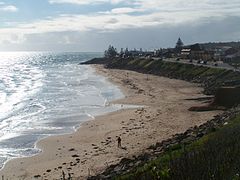
This is a picture form the Witton Bluff overlooking the coast of Christies Beach, SA
Coat of arms of the city of Adelaide, in Australia
Autor: User:Martyman, Licencja: CC-BY-SA-3.0
Locator Map for Adelaide-LGA-Onkaparinga-MJC.png
Drawn by me in Illustrator and released under the GFDL


