City of Port Adelaide Enfield

City of Port Adelaide Enfield
obszar samorządu lokalnego
Ilustracja
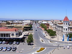
Ulica Commercial Road w Port Adelaide
Państwo Australia
Stan Australia Południowa
Powierzchnia97 km²
Populacja (2006)
• liczba ludności

102928
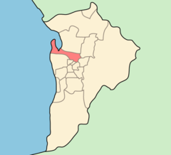
Położenie na mapie Adelaide
Położenie na mapie
Strona internetowa
Portal Australia

City of Port Adelaide Enfield – jednostka samorządowa wchodząca w skład aglomeracji Adelaide. Powstała w 1996 z połączenia Port Adelaide oraz Enfield.

Rozciąga się od rzeki Torrens, aż do dzielnicy Outer Harbor, łączna powierzchnia obszaru wynosi 97 km². Obszar ten zamieszkuje 102928 osób (dane z 2006[1]).

Dzielnice

W nawiasach podany jest kod pocztowy.

  • Alberton (5014)
  • Angle Park (5010)
  • Birkenhead (5015)
  • Blair Athol (5084)
  • Broadview (5083)
  • Clearview (5085)
  • Croydon Park (5008)
  • Dernancourt (5075)
  • Devon Park (5008)
  • Dry Creek (5094)
  • Dudley Park (5008)
  • Enfield (5085)
  • Ethelton (5015)
  • Exeter (5019)
  • Ferryden Park (5010)
  • Gepps Cross (5094)
  • Gilles Plains (5086)
  • Gillman (5013)
 
  • Glanville (5015)
  • Greenacres (5086)
  • Hampstead Gardens (5086)
  • Hillcrest (5086)
  • Holden Hill (5088)
  • Kilburn (5084)
  • Klemzig (5087)
  • Largs Bay (5016)
  • Largs North (5016)
  • Manningham (5086)
  • Mansfield Park (5012)
  • Northfield (5085)
  • Northgate (5085)
  • North Haven (5018)
  • Oakden (5086)
  • Osborne (5017)
 
  • Ottoway (5013)
  • Outer Harbor (5018)
  • Peterhead (5016)
  • Port Adelaide (5015)
  • Queenstown (5014)
  • Regency Park (5010)
  • Rosewater (5013)
  • Sefton Park (5083)
  • Semaphore (5019)
  • Semaphore South (5019)
  • Taperoo (5017)
  • Valley View (5093)
  • Walkley Heights (5098)
  • Windsor Gardens (5087)
  • Wingfield (5013)
  • Woodville Gardens (5012)

Zobacz też

  • Podział aglomeracji Adelaide

Przypisy

Media użyte na tej stronie

Escudo de Adelaida.png
Coat of arms of the city of Adelaide, in Australia
Commercial Road Port Adelaide from the lighthouse 2007.jpg
Autor: Peripitus, Licencja: CC-BY-SA-3.0
View down commercial road, Port Adelaide, South Australia from the waterside lighthouse
Adelaide-LGA-Port Adelaide-MJC.png
Autor: User:Martyman, Licencja: CC-BY-SA-3.0

Locator Map for Adelaide-LGA-Port Adelaide-MJC.png

Drawn by me in Illustrator and released under the GFDL