City of Preston
| dystrykt niemetropolitalny | |||
 Preston | |||
| |||
| Państwo | |||
|---|---|---|---|
| Kraj | |||
| Region | |||
| Hrabstwo | |||
| Siedziba | |||
| Powierzchnia | 142 km² | ||
| Populacja (2016) • liczba ludności |
| ||
| • gęstość | 999 os./km² | ||
| Plan | |||
Nilfanion and Dr Greg. © OpenStreetMap contributors. Contains Ordnance Survey data © Crown copyright and database right 2012., CC BY-SA 4.0 | |||
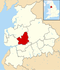
| Położenie na mapie Lancashire Contains Ordnance Survey data © Crown copyright and database right, CC BY-SA 3.0 | |||
| Strona internetowa | |||
| Portal | |||
Preston – dystrykt w hrabstwie Lancashire w Anglii.
Podział administracyjny
- 1 Preston Rural North
- 1A Barton
- 1B Goosnargh
- 1C Whittingham
- 1D Woodplumpton
- 2 Preston Rural East
- 2A Broughton
- 2B Grimsargh
- 2C Haighton
- 3 Lea
- 1A Barton
Miasta
Inne miejscowości
Barton, Broughton, Catforth, Eaves, Goosnargh, Grimsargh, Inglewhite, Whitechapel, Woodplumpton.
Przypisy
- ↑ Population Estimates for UK, England and Wales, Scotland and Northern Ireland - Office for National Statistics, www.ons.gov.uk [dostęp 2017-10-21] (ang.).
Media użyte na tej stronie
Flag of England. Saint George's cross (a red cross on a white background), used as the Flag of England, the Italian city of Genoa and various other places.
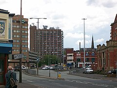
I took this photo myself on a recent visit to Preston.
Nilfanion and Dr Greg. © OpenStreetMap contributors. Contains Ordnance Survey data © Crown copyright and database right 2012., CC BY-SA 4.0
Map of civil parishes, council divisions and electoral wards in the City of Preston district, Lancashire, England.
Equirectangular map projection on WGS 84 datum
Geographic limits:
- West: 2.83 ºW
- East: 2.59 ºW
- North: 53.90 ºN
- South: 53.74 ºN
- Key
- 1. Preston Rural North
- 1a. Barton
- 1b. Goosnargh
- 1c. Whittingham
- 1d. Woodplumpton
- 2. Preston Rural East
- 22. Lea
Autor: Nieznany, Licencja: CC BY-SA 4.0
The coat of arms of Preston City Council, the local authority for the City of Preston, in Lancashire, England.
Contains Ordnance Survey data © Crown copyright and database right, CC BY-SA 3.0
Map of Lancashire, UK with Preston highlighted.
Equirectangular map projection on WGS 84 datum, with N/S stretched 165%


