City of Salford
| dystrykt metropolitalny | |||
 Salford | |||
| |||
| Państwo | |||
|---|---|---|---|
| Kraj | |||
| Region | |||
| Hrabstwo | |||
| Siedziba | |||
| Powierzchnia | 97 km² | ||
| Populacja (2016) • liczba ludności |
| ||
| • gęstość | 2564 os./km² | ||
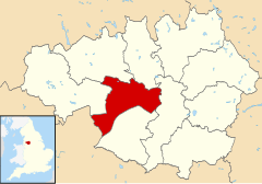
| Położenie na mapie Wielkiego Manchesteru Contains Ordnance Survey data © Crown copyright and database right, CC BY-SA 3.0 | |||
| Strona internetowa | |||
| Portal | |||
Salford – dystrykt metropolitalny w hrabstwie ceremonialnym Wielki Manchester w Anglii[2].
Miasta
Inne miejscowości
- Barton upon Irwell, Ellenbrook, Kersal, Little Hulton, Ordsall, Pendlebury, Roe Green, Winton.
Przypisy
- ↑ Population Estimates for UK, England and Wales, Scotland and Northern Ireland - Office for National Statistics, www.ons.gov.uk [dostęp 2017-10-21] (ang.).
- ↑ Ordnance Survey linked data
Media użyte na tej stronie
Flag of England. Saint George's cross (a red cross on a white background), used as the Flag of England, the Italian city of Genoa and various other places.
Autor: Ta PNG grafika rastrowa została stworzona za pomocą Inkscape., Licencja: CC BY-SA 3.0
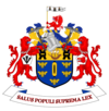
The Coat of arms of Salford City Council, the local government authority for the City of Salford, in Greater Manchester, England. The blazon is:
ARMS: Azure a Shuttle erect between five Bees volant two two and one on a Chief Or a three-masted Ship of the 19th century in full sail proper between two Millrinds Sable.
CREST: On a Wreath of the Colours a demi Griffin Gules gorged with a Collar of Steel proper supporting a Staff Or flying therefrom a forked Pennon Argent charged with three Boars' Heads erased and erect in Fess Sable langued Gules.
Salford Old Town Hall, the former HQ of Salford City Council. Now the magistrates courts.
Contains Ordnance Survey data © Crown copyright and database right, CC BY-SA 3.0
Map of Greater Manchester, UK with Salford highlighted.
Equirectangular map projection on WGS 84 datum, with N/S stretched 165%


