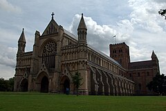
City of St. Albans
| dystrykt niemetropolitalny | |
 | |
| Państwo | |
|---|---|
| Kraj | |
| Region | East of England |
| Hrabstwo | Hertfordshire |
| Siedziba | St Albans |
| Powierzchnia | 161,18 km² |
| Populacja (2011) • liczba ludności | 141 200 |
| • gęstość | 880 os./km² |
| Położenie na mapie Hertfordshire Contains Ordnance Survey data © Crown copyright and database right, CC BY-SA 3.0 | |
| Strona internetowa | |
| Portal | |
St Albans (ang. City and District of St Albans także: City of St Albans lub District of St Albans) - utworzony 1 kwietnia 1974 dystrykt niemetropolitalny w hrabstwie Hertfordshire w Anglii. Władze dystryktu (Rada Dystryktu i Miasta St Albans, ang. St Albans District & City Council) znajdują się w St Albans. Kodem pocztowym dystryktu jest AL i następująca po nim seria liczb i liter.
Geografia
Dystrykt składa się z miasta St Albans (ponad 64 tys. mieszkańców[1]), miasta Harpenden (ok. 27 600 mieszkańców) oraz parafii: Colney Heath, Harpenden Rural, London Colney, Redbourn, St Michael's, St Stephen's (włączając w to wsie Chiswell Green i Bricket Wood), Sandridge oraz Wheathampstead.
Populacja
Populacja dystryktu St Albans (ang. District of St Albans)[2].
1801-1911
| Rok | Liczba ludności | Przyrost (%) |
|---|---|---|
| 1801 | 9834 | — |
| 1811 | 11 214 | 14,0 |
| 1821 | 14 114 | 25,9 |
| 1831 | 15 83 | 12,2 |
| 1841 | 17 048 | 7,7a |
| 1851 | 18 004 | 5,6 |
| 1861 | 18 926 | 5,1 |
| 1871 | 21 079 | 11,4 |
| 1881 | 23 296 | 10,5b |
| 1891 | 26 872 | 15,4 |
| 1901 | 33 008 | 22,8 |
| 1911 | 43 768 | 32,6 |
a) W roku 1835 zredukowano granice dystryktu.
b) W roku 1879 zredukowano granice dystryktu.
1901-1971
Populacja Miasta i Dystryktu St Albans (ang. City and District of St Albans). W roku 1974 zmieniono podział administracyjny. Dane dla lat 1961 i 1971 odnoszą się do obszaru nowego Miasta i Dystryktu St Albans[3]. Populacja Wiejskiego Dystryktu St Albans (ang. St Albans Rural District)[2].
| Rok | Liczba ludności | Przyrost (%) |
|---|---|---|
| 1901 | 12 264 | — |
| 1911 | 19 463 | 58,7 |
| 1921 | 14 533 | -25,3c |
| 1931 | 19 578 | 34,7 |
| 1939 | 26 158 | 33,6d |
| 1951 | 28 608 | 9,4 |
| 1961 | 38 947 | 36,1e |
| 1971 | 45 350 | 16,4 |
c) W roku 1913 zredukowano granice dystryktu.
d) W roku 1935 poszerzono granice dystryktu. e) W roku 1961 zmieniono granice dystryktu.
1961-2001
Populacja Miasta i Dystryktu St Albans (ang. City and District of St Albans). W roku 1974 zmieniono podział administracyjny. Dane dla lat 1961 i 1971 odnoszą się do obszaru nowego Miasta i Dystryktu St Albans[3].
| Rok | Liczba ludności | Przyrost (%) |
|---|---|---|
| 1961 | 107 458 | — |
| 1971 | 121 359 | 12,9 |
| 1981 | 125 124 | 3,1 |
| 1991 | 126 202 | 0,9 |
| 2001 | 121 359 | 2,2 |
Zobacz też
Przypisy
- ↑ Office for National Statistics, 2001 Census, Key Statistics for HCC Settlements #. Crown copyright. Table KS01 Usual resident population (numbers). [dostęp 2016-03-03]. [zarchiwizowane z tego adresu (2016-03-03)].
- ↑ a b Mark Freeman: St Albans. A history. Lancaster: Carnegie Publishing Ltd, 2008, s. 210. ISBN 978-185936-190-0.
- ↑ a b Mark Freeman: St Albans. A history. Lancaster: Carnegie Publishing Ltd, 2008, s. 299. ISBN 978-185936-190-0.
Linki zewnętrzne
Media użyte na tej stronie
Flag of England. Saint George's cross (a red cross on a white background), used as the Flag of England, the Italian city of Genoa and various other places.
Autor: Przemysław Sakrajda, Licencja: CC BY-SA 3.0
The population of the City & District of St Albans (1961-2001).
Contains Ordnance Survey data © Crown copyright and database right, CC BY-SA 3.0
Map of Hertfordshire, UK with St Albans highlighted.
Equirectangular map projection on WGS 84 datum, with N/S stretched 160%


