City of Tea Tree Gully
| Ten artykuł od 2012-09 wymaga zweryfikowania podanych informacji. |
| obszar samorządu lokalnego | |
 Osiedle Gulfview Heights | |
| Państwo | |
|---|---|
| Stan | |
| Powierzchnia | 95,21 km² |
| Populacja (2001) • liczba ludności | 95102 |
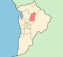
Położenie na mapie Adelaide | |
| Strona internetowa | |
| Portal | |
City of Tea Tree Gully – jednostka samorządowa wchodząca w skład aglomeracji Adelaide, położona na północny wschód od centrum. Obszar ten zamieszkuje 95102 osób (dane z 2001) i jest jednocześnie jednym z najbardziej zaludnionych samorządem terytorialnym w Adelaide, powierzchnia wynosi 95.21 km².
Dzielnice
W nawiasach podany jest kod pocztowy.
|
|
Zobacz też
- Podział aglomeracji Adelaide
Media użyte na tej stronie
Autor: User:Martyman, Licencja: CC-BY-SA-3.0
Locator Map for Adelaide-LGA-Tea Tree Gully-MJC.png
Drawn by me in Illustrator and released under the GFDLCoat of arms of the city of Adelaide, in Australia
Autor: Peripitus, Licencja: CC-BY-SA-3.0
House in Gulfview Heights, South Australia


