Claira
| miejscowość i gmina | |||
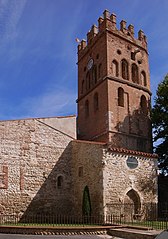
 Kościół św. Wincenta w Claira, 2008 | |||
| |||
| Państwo | |||
|---|---|---|---|
| Region | |||
| Departament | |||
| Okręg | |||
| Kod INSEE | 66050 | ||
| Powierzchnia | 19,42 km² | ||
| Populacja (1990) • liczba ludności |
| ||
| • gęstość | 109 os./km² | ||
| Kod pocztowy | 66530 | ||
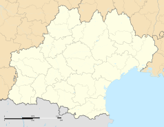
Położenie na mapie Pirenejów Wschodnich © Hawk-Eye, CC BY-SA 3.0 | |||
| Strona internetowa | |||
| Portal | |||
Claira – miejscowość i gmina we Francji, w regionie Oksytania, w departamencie Pireneje Wschodnie[1]. Przez miejscowość przepływa rzeka Agly[2].
Według danych na rok 1990 gminę zamieszkiwało 2117 osób, a gęstość zaludnienia wynosiła 109 osób/km² (wśród 1545 gmin Langwedocji-Roussillon Claira plasuje się na 183. miejscu pod względem liczby ludności, natomiast pod względem powierzchni na miejscu 396.).
Populacja
Przypisy
- ↑ Atlas Routier France 2014. Michelin, s. 339. ISBN 978-2-06-719261-4. (fr.).
- ↑ Fiche cours d'eau / L'Agly (Y06-0400). SANDRE. [dostęp 2016-06-23]. (fr.).
Bibliografia
- Francuski urząd statystyczny. (fr.).
Media użyte na tej stronie
© Hawk-Eye, CC BY-SA 3.0
Blank administrative map of the department of Pyrénées-Orientales, France, for geo-location purpose.
Autor: Superbenjamin, Licencja: CC BY-SA 4.0
Blank administrative map of France for geo-location purpose, with regions and departements distinguished. Approximate scale : 1:3,000,000
Autor: Flappiefh, Licencja: CC BY-SA 4.0
Carte administrative vierge de la région Languedoc-Roussillon-Midi-Pyrénées, France, destinée à la géolocalisation.
Autor: Oosoom, Licencja: CC BY-SA 3.0
The church of Saint Vincent in Claira, in the Pyrénées-Orientales département, in southwestern France. Transformed to improve perspective distortion.
Autor: Chatsam, Licencja: CC BY-SA 3.0
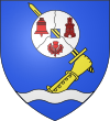
blason de la commune de Claira : D'azur au dextrochère armé d'une épée haute posée en bande, le tout d'or, issant d'une burelle ondée d'argent en pointe; à la meule de moulin d'argent percée du champ, brochant sur l'épée, tiercée en pairle ondé renversé par un filet de sable, chargée au 1er d'une cloche de gueules, au 2e d'une tour donjonnée du même, ouverte et ajourée d'argent, au 3e d'un chardon de gueules.
Autor: Michiel1972, Licencja: CC BY-SA 3.0
Population - Municipality code 66050.svg
Population Census 1962-2008


