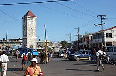
Clarendon (region Jamajki)
| region | |
 | |
| Państwo | |
|---|---|
| Hrabstwo | |
| Siedziba | May Pen |
| Powierzchnia | 1 196 km² |
| Populacja (2001) • liczba ludności |
|
| • gęstość | 198,18 os./km² |
Położenie na mapie Jamajki | |
Clarendon – jeden z 14 regionów Jamajki. Znajduje się na południu wyspy.
Linki zewnętrzne
- Strona o Claredon. mfaft.gov.jm. [zarchiwizowane z tego adresu (2006-03-20)]. (en)
Media użyte na tej stronie
Flag of Jamaica.svg
Flag of Jamaica. “The sunshine, the land is green, and the people are strong and bold” is the symbolism of the colours of the flag. GOLD represents the natural wealth and beauty of sunlight; GREEN represents hope and agricultural resources; BLACK represents the strength and creativity of the people. The original symbolism, however, was "Hardships there are, but the land is green, and the sun shineth", where BLACK represented the hardships being faced.
Flag of Jamaica. “The sunshine, the land is green, and the people are strong and bold” is the symbolism of the colours of the flag. GOLD represents the natural wealth and beauty of sunlight; GREEN represents hope and agricultural resources; BLACK represents the strength and creativity of the people. The original symbolism, however, was "Hardships there are, but the land is green, and the sun shineth", where BLACK represented the hardships being faced.
May pen town cente 1 galleryfull.jpg
Autor: Oryginalnym przesyłającym był Ukblackout z angielskiej Wikipedii, Licencja: CC BY-SA 3.0
May Pen, Jamaica, town centre
Autor: Oryginalnym przesyłającym był Ukblackout z angielskiej Wikipedii, Licencja: CC BY-SA 3.0
May Pen, Jamaica, town centre
Clarendon in Jamaica.svg
Autor: TUBS
 ,
Licencja: CC BY-SA 3.0 de
Location of parish xy (see filename) in Jamaica.
Autor: TUBS
Location of parish xy (see filename) in Jamaica.


