Cmentarz Brompton
 | |
| Państwo | |
|---|---|
| Kraj | |
| Miejscowość | |
| Adres | Fulham Road, |
| Stan cmentarza | czynny |
| Powierzchnia cmentarza | 16 ha |
| Data otwarcia | 1840 |
Położenie na mapie gminy Kensington and Chelsea  Contains Ordnance Survey data © Crown copyright and database right, CC BY-SA 3.0 | |
Położenie na mapie Wielkiej Brytanii  (c) Karte: NordNordWest, Lizenz: Creative Commons by-sa-3.0 de | |
Położenie na mapie Anglii  | |
Położenie na mapie Wielkiego Londynu  Contains Ordnance Survey data © Crown copyright and database right, CC BY-SA 3.0 | |
Cmentarz Brompton (ang. Brompton Cemetery) – cmentarz w Londynie, w Royal Borough of Kensington and Chelsea, wytyczony w 1839, otwarty w 1840.
Znajduje się przy ulicy Old Brompton Road[1] w zachodniej części miasta na terenie obszaru West Brompton w pobliżu dzielnicy Earl’s Court. Został zaprojektowany w 1839 przez inżyniera Stephen Geary, architektem był Benjamin Baud, a sam ogród był wedle planu John Loudun. Otwarty został w 1840 roku. Stanowi jeden z siedmiu wspaniałych cmentarzy wokół Londynu, z trzeciego dziesięciolecia 19-go wieku i do których zaliczają się Cmentarz Kensal Green, Highgate Cemetery oraz Cmentarz West Norwood. Na początku jego istnienia posadzono tu polskie drzewka iglaste aby na groby nie opadały liście[2][3]. Jest przeszło 300 polskich grobów[4], wśród 205 000 pochówków. Najwcześniejszym Polakiem, który trafił tam na wieczność był międzynarodowy szachista i dziennikarz, Jan Herman Zuckertort (1842–1888).
Notowane groby
- Franciszek Arciszewski – generał, poseł na Sejm III
- Stanisław Rola-Arciszewski – publicysta wojskowy
- Tomasz Arciszewski – polityk
- Antoni (Bloom) – arcybiskup i lekarz
- Henry Cole – fundator Victoria and Albert Museum i Royal Albert Hall,
- Joseph Thomas Clover – pionier anestezji
- Samuel Cunard – fundator Cunard Line
- Stefan Dąb-Biernacki – legionista
- Charles Fremantle – fundator miasta Fremantle w Australii
- Robert Fortune – botanik, przywiózł krzewy kamelii-herbaty z Chin do Indii
- Sir John Fowler – inżynier kolejowy zaprojektował Forth Bridge
- Janusz Głuchowski – generał
- Michał Karaszewicz-Tokarzewski – wojskowy, teozof
- Dr. Antoni Kutek – oficer marynarki i lekarz za czasu wojny na Batorym
- Constant Lambert – Kompozytor
- Wiktor Łomidze – Gruzin w Marynarce Polskiej
- Teresa Łubieńska – działaczka społeczna
- Karol Masny – generał
- Mateusz (Siemaszko) – biskup
- Roderick Murchison – geolog
- Stanisław Julian Ostroróg – fotograf
- Emmeline Pankhurst – sufrażystka
- Zygmunt Podhorski – generał
- Alfred Prager – legionista
- Jan Prot – chemik
- Bronisław Regulski – generał
- Sawa (Sowietow) – biskup
- Felicjan Sławoj Składkowski – premier Polski
- Samuel Smiles – pisarz
- John Snow – epidemiolog
- Stanisław Sołtykiewicz – rotmistrz
- Alfred Spett – inżynier saper
- Ludwik Stankiewicz – wojskowy
- Nikodem Sulik – generał
- Jerzy Świrski – wiceadmirał Marynarki Wojennej
- Richard Tauber – tenor
- Frederic Thesiger (2. baron Chelmsford) – generał
- Józef Trenkwald – Olimpijczyk
- Stefan Tyszkiewicz – inżynier
- Andrew Scott Waugh – topograf wojskowy, ochrzcił górę jako Everest
- Elizabeth Alice Hawkins-Whitshed - alpinistka
- Bob Carlos Williams – fotograf
- Sergiusz Zahorski – generał
- Johannes Zukertort lub Jan Hermann Cukiertort – szachista
Przypisy
- ↑ Contact (ang.). brompton-cemetery.org.uk. [dostęp 2015-04-03]. [zarchiwizowane z tego adresu (6 kwietnia 2015)].
- ↑ History (ang.). [dostęp 2016-04-09].
- ↑ History (ang.). brompton-cemetery.org.uk. [dostęp 2015-04-03]. [zarchiwizowane z tego adresu (6 kwietnia 2015)].
- ↑ „Non omnis moriar"--: Polacy na londyńskim cmentarzu Brompton, Andrzej Suchcitz, Warszawa: Oficyna Wydawnicza „Audiutor”, 1992.
Bibliografia
- Karolina Grodziska, Polskie groby na cmentarzach Londynu: Brompton Cemetery, w: Rocznik Biblioteki PAN w Krakowie, 1993, ISSN 0079-3140
Galeria
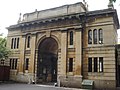
Północna brama wejściowa do cmentarza Brompton
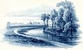
Malowany widok cmentarza Brompton i kanał 'Kensington' – William Cowen 1840

Kaplica w Brompton Cemetery
 (c) Derek Harper, CC BY-SA 2.0
Galeria w Brompton Cemetery
 (c) Derek Harper, CC BY-SA 2.0
Widok Brompton Cemetery
 (c) R Sones, CC BY-SA 2.0
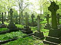
Groby, Brompton Cemetery

Grób Emmeline Pankhurst, Brompton Cemetery
Media użyte na tej stronie
(c) Karte: NordNordWest, Lizenz: Creative Commons by-sa-3.0 de
Location map of the United Kingdom
Contains Ordnance Survey data © Crown copyright and database right, CC BY-SA 3.0
Map of Greater London, UK with the following information shown:
- Administrative borders
- Coastline, lakes and rivers
- Roads and railways
- Urban areas
The data includes both primary routes and railway lines.
Equirectangular map projection on WGS 84 datum, with N/S stretched 160%
Geographic limits:
- West: 0.57W
- East: 0.37E
- North: 51.72N
- South: 51.25N


Flag of England. Saint George's cross (a red cross on a white background), used as the Flag of England, the Italian city of Genoa and various other places.

Symbol miejsca kultu do legendy mapy

Autor: Edwardx, Licencja: CC BY-SA 3.0
This is a photo of listed building number

(c) R Sones, CC BY-SA 2.0
Among the gravestones, Brompton Cemetery SW10

Autor: Edwardx, Licencja: CC BY-SA 3.0
This is a photo of listed building number

brompton-cemetery-15c and Kensington Canal by William Cowen (18 June, 1791 – 29 January, 1864) a Rotherham born landscape painter.
Contains Ordnance Survey data © Crown copyright and database right, CC BY-SA 3.0
Blank map of the Royal Borough of Kensington and Chelsea, showing electoral wards.
Equirectangular map projection on WGS 84 datum, with N/S stretched 160%
Geographic limits:
- West: 0.235W
- East: 0.145W
- North: 51.535N
- South: 51.475N

(c) Derek Harper, CC BY-SA 2.0
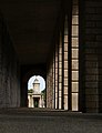
Brompton Cemetery. An octagonal tower is glimpsed along one of the colonnades. Like the chapel shown in 1447176, this was designed by Benjamin Baud and built in 1839-40.

Autor: Edwardx, Licencja: CC BY-SA 3.0
This is a photo of listed building number
Autor: Edwardx, Licencja: CC BY-SA 3.0
This is a photo of listed building number

(c) Derek Harper, CC BY-SA 2.0
Brompton Cemetery The cemetery is an important haven for wildlife, and the policy of allowing grass and wild flowers to grow freely in some areas must contribute enormously. This scene is to the west of the South Lodge.