Colosseo
 | |
| Państwo | |
|---|---|
| Data otwarcia | 10 lutego 1955 |
| Linia B | |
| Poprzednia stacja | |
| Następna stacja | |
| Portal | |
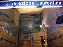
Colosseo - linii B metra rzymskiego. Stacja została otwarta w 1955. Znajduje się w pobliżu Koloseum. Poprzednim przystankiem jest Cavour, a następnym Circo Massimo.
Media użyte na tej stronie
Autor: NordNordWest, Licencja: CC BY-SA 3.0
Location map of Italy (Commons photos) → en-Wikipedia Italy.
Icon of Rome underground line A.
Icon of Rome underground line B.
Icon of Rome underground line B, branch B1.
Autor:
- Map_of_region_of_Lazio,_Italy.svg: User:Vonvikken
- derivative work: Milenioscuro (talk)
Location map of Lazio region (Italy)
Autor: Dr. Blofeld, insert originally by Nordnordwest, Licencja: CC BY-SA 2.0
Map of Rome. Italy
Geographic limits of the map:
- N: 41.993°
- S: 41.792°
- W: 12.308°
- E: 12.685°
Icon of Rome underground line C.
Autor: Lalupa, Licencja: CC-BY-SA-3.0
Roma, Metropolitana linea B: stazione Colosseo
Logo delle metropolitane in Italia


