Conca
| gmina | |
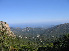
 Conca leżąca w dolinie pomiędzy dwoma pasmami górskimi. | |
| Państwo | |
|---|---|
| Region | |
| Departament | |
| Okręg | |
| Kod INSEE | 2A092 |
| Powierzchnia | 78,3 km² |
| Populacja (1999) • liczba ludności |
|
| • gęstość | 10 os./km² |
| Kod pocztowy | 20135 |
| Portal | |
Conca – miejscowość i gmina we Francji, w regionie Korsyka, w departamencie Korsyka Południowa. Conca, oddalona 20 kilometrów od Porto-Vecchio sprawia wrażenie idyllicznej i zapomnianej miejscowości.
W Conca kończy się pieszy szlak wędrowny GR 20, uważany najtrudniejszy szlak w Europie.
Według danych na rok 1990 gminę zamieszkiwały 783 osoby, a gęstość zaludnienia wynosiła 10 osób/km².
Zobacz też
Bibliografia
- Francuski urząd statystyczny. (fr.).
Linki zewnętrzne
Media użyte na tej stronie
Autor: Superbenjamin, Licencja: CC BY-SA 4.0
Blank administrative map of France for geo-location purpose, with regions and departements distinguished. Approximate scale : 1:3,000,000
Autor: Eric Gaba (Sting - fr:Sting), Licencja: CC BY-SA 3.0
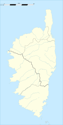
Blank administrative map of the region of Corsica, France, for geo-location purpose, with distinct boundaries for departments and arrondissements as they are since January 2010.
The former version of the map shows the boundaries as they were until December 2009.
Autor: Eric Gaba (Sting - fr:Sting), Licencja: CC BY-SA 3.0
Blank administrative map of the department of Corse-du-Sud, France, for geo-location purpose, with distinct boundaries for departments and arrondissements.


