Conwy (hrabstwo miejskie)
| hrabstwo miejskie | |
 | |
| Państwo | |
|---|---|
| Księstwo | |
| Siedziba | |
| Powierzchnia | 1 130 km² |
| Populacja • liczba ludności |
|
| • gęstość | 99 os./km² |
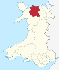
Położenie na mapie Walii | |
| Portal | |
Conwy – hrabstwo miejskie w północnej Walii. Od wschodu graniczy z hrabstwem Denbighshire a od zachodu z hrabstwem Gwynedd.
Miejscowości
Na terenie hrabstwa znajdują się następujące miejscowości[1][2] (w nawiasach liczba ludności w 2011[3]):
- Colwyn Bay (29 405)
- Llandudno (15 371)
- Llandudno Junction (10 658)
- Kinmel Bay (9497)
- Abergele (9208)
- Penrhyn Bay (4432)
- Conwy (3873)
- Llanfairfechan (3637)
- Llanrwst (3323)
- Penmaenmawr (2535)
- Llansanffraid Glan Conwy (1735)
- Dwygyfylchi (1355)
- Llanddulas (1268)
- Mynydd Marian (1076)
- Trefriw (605)
- Bryn Pydew (451)
- Penrhyn-side (447)
- Dolgarrog (446)
- Llysfaen (330)
- Betws-yn-Rhos (312)
- Cerrigydrudion (289)
- Betws-y-Coed (255)
Mapa
Przypisy
- ↑ a b Office for National Statistics: Built-up Area to Local Authority District (December 2011) Lookup in England and Wales (ang.). W: Open Geography Portal [on-line]. [dostęp 2022-06-05].
- ↑ a b Office for National Statistics: Built-up Area Sub Divisions (December 2011) Boundaries (ang.). W: Open Geography Potal [on-line]. [dostęp 2022-06-05].
- ↑ a b Office for National Statistics: KS101EW - Usual resident population (ang.). W: 2011 Census [on-line]. Nomis – Official labour market statistics, 2013-02-12. [dostęp 2022-06-05].
Media użyte na tej stronie
Autor: TUBS
Location of unitary authority area Conwy in Wales in Wales.
Contains Ordnance Survey data © Crown copyright and database right, CC BY-SA 3.0
Blank map of Conwy, UK with the following information shown:
- Administrative borders
- Coastline, lakes and rivers
- Roads and railways
- Urban areas
Equirectangular map projection on WGS 84 datum, with N/S stretched 165%
Geographic limits:
- West: 4.23W
- East: 3.40W
- North: 53.35N
- South: 52.90N


