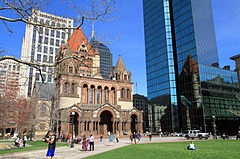
Copley Square
 | |
| Państwo | |
|---|---|
| Miejscowość | |
Copley Square (Boston) – plac w okolicy Boston's Back Bay w Bostonie, Massachusetts, w Stanach Zjednoczonych, nazwany na cześć malarza Johna Singletona Copleya, otoczony ulicami Boylston Street, Clarendon Street, St. James Avenue, i Dartmouth Street.
Zamach podczas maratonu w Bostonie
15 kwietnia 2013 roku około 14:45 w okolicy placu Copley Square miał miejsce zamach podczas maratonu. Zginęły trzy osoby, a 264 osób zostało rannych[1].
Przypisy
- ↑ Reuters: Boston officials say 264 injured in marathon bombing (ang.). reuters.com, 22 kwietnia 2013. [dostęp 2013-04-26].
Linki zewnętrzne
- Copley Square Farmers' Market site
- Friends of Copley Square
- Boston Public Library Copley Square Collection. bpl.org. [zarchiwizowane z tego adresu (2013-07-05)].
- Copley Square: The Story of Boston's Art Square. friendsofcopleysquare.org. [zarchiwizowane z tego adresu (2013-05-28)].
Media użyte na tej stronie
Autor: Uwe Dedering, Licencja: CC BY-SA 3.0
Location map of the USA (without Hawaii and Alaska).
EquiDistantConicProjection:
Central parallel:
* N: 37.0° N
Central meridian:
* E: 96.0° W
Standard parallels:
* 1: 32.0° N
* 2: 42.0° N
Made with Natural Earth. Free vector and raster map data @ naturalearthdata.com.
Formulas for x and y:
x = 50.0 + 124.03149777329222 * ((1.9694462586094064-({{{2}}}* pi / 180))
      * sin(0.6010514667026994 * ({{{3}}} + 96) * pi / 180))
y = 50.0 + 1.6155950752393982 * 124.03149777329222 * 0.02613325650382181
      - 1.6155950752393982  * 124.03149777329222 *
     (1.3236744353715044  - (1.9694462586094064-({{{2}}}* pi / 180))
      * cos(0.6010514667026994 * ({{{3}}} + 96) * pi / 180))
Autor: Alexrk2, Licencja: CC BY 3.0
Location map of Massachusetts, USA
The flag of Navassa Island is simply the United States flag. It does not have a "local" flag or "unofficial" flag; it is an uninhabited island. The version with a profile view was based on Flags of the World and as a fictional design has no status warranting a place on any Wiki. It was made up by a random person with no connection to the island, it has never flown on the island, and it has never received any sort of recognition or validation by any authority. The person quoted on that page has no authority to bestow a flag, "unofficial" or otherwise, on the island.
Crossroads with a major road ahead.
Autor: OpenStreetMap contributors, Licencja: CC BY-SA 2.0
Map of the central area of Boston and Cambridge, exported from OpenStreetMap.


