Corrientes (miasto)
 | |||||
| Państwo | |||||
|---|---|---|---|---|---|
| Prowincja | |||||
| Burmistrz | Carlos José Vignolo | ||||
| Powierzchnia | 500 km² | ||||
| Wysokość | 52 m n.p.m. | ||||
| Populacja (2013) • liczba ludności • gęstość | 372 754 745 os./km² | ||||
| Nr kierunkowy | 03783 | ||||
| Kod pocztowy | W3400 | ||||
| Strona internetowa | |||||
Corrientes to miasto w północno-wschodniej Argentynie, ważny port nad Paraną, przy ujściu Paragwaju, stolica prowincji Corrientes. Około 328,7 tys. mieszkańców.
Miasto jest siedzibą klubów piłkarskich Boca Unidos, Deportivo Mandiyú i Huracán.
Współpraca
Media użyte na tej stronie
Autor:
- CNQ1.JPG: User:Claudio Elias
- Puente_General_Belgrano_al_atardecer.jpg: Ramona Chavez
- Patio_interior_Casa_de_Gobierno_Corrientes.jpeg: © 2006 Carla Antonini
- Palacio_San_Martín_Corrientes.jpeg: © 2006 Carla Antonini
- Plaza_Cabral,_Corrientes.jpg: User:Alpertron
- derivative work: J. Allermann
Corrientes City, Argentina
Flag of Corrientes Province, Argentina.
Autor: Abyssmanx, Licencja: CC BY-SA 4.0
The flag of the city of Corrientes, capital of the province of Corrientes, from the country of Argentina.
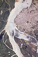
The city of Corrientes, capital of the province of the same name, in the Argentine Mesopotamia (litoral region in the north-east of the country), on the eastern shore of the Paraná River. Picture taken from the International Space Station.
- Corrientes, Argentina, and the Parana River are featured in this image photographed by an Expedition 10 crewmember on the International Space Station (ISS). Corrientes, Argentina sits on the east bank of the Parana River, South America’s third largest river (after the Negro and Amazon Rivers). From its headwaters in southeastern Brazil, the river flows southwestward around southern Paraguay, and then into Argentina. Corrientes is located just inside Argentina, across the river from the southwestern tip of Paraguay. The bridge over the Parana, built in the 1970s, connects Corrientes to its sister city, Resistencia, (beyond the left edge of image) on the western bank of the river. Sun glint on the river gives it a silvery glow and emphasizes channel islands in the river, side channels, and meander scars on the floodplain opposite the city, and even reveals the pattern of disturbed flow downstream of the bridge pylons. The old part of the city appears as a zone of smaller, more densely clustered city blocks along the river to the north of a major highway, which runs through Corrientes from the General Belgrano Bridge to the northeast (upper right of image). Larger blocks of the younger cityscape, with more green space, surround these core neighborhoods.
Autor:
- Argentina_location_map.svg: NordNordWest
- Map_of_Corrientes_Province.svg: Pertile
- derivative work: Milenioscuro
Location map of Corrientes province (Argentina)
Escudo de la Ciudad de Corrientes, Provincia de Corrientes, Argentina.


