Corsham
 High Street | |
| Państwo | |
|---|---|
| Kraj | |
| Hrabstwo | |
| Populacja (2002) • liczba ludności |
|
| Nr kierunkowy | 01249 |
| Kod pocztowy | SN13 |
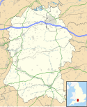
Położenie na mapie Wiltshire Contains Ordnance Survey data © Crown copyright and database right, CC BY-SA 3.0 | |
Położenie na mapie Wielkiej Brytanii (c) Karte: NordNordWest, Lizenz: Creative Commons by-sa-3.0 de | |
| Strona internetowa | |
| Portal | |
Corsham - miasto w Wielkiej Brytanii, w Anglii w hrabstwie Wiltshire położone na południowym wschodzie wzgórz Cotswolds przy autostradzie M4, między Bath a Chippenham. Przez miasto przebiega linia kolejowa Bristol Temple Meads - Londyn. Miasto zamieszkuje ok. 12 tys. osób[1].
Historia
Pojawia się już w Domesday Book z roku 1086 jako Cosseham[2]. W średniowieczu miasto było ośrodkiem handlu wełną. Po upadku tej branży, miasto prosperowało dzięki kamieniołomom eksploatowanym dla wapienia o charakterystycznej złotej barwie, zwanego Bath Stone.
Miasta partnerskie
Przypisy
- ↑ Council Tax 2008/2009 (ang.). [dostęp 2008-11-05].
- ↑ Wiltshire Community History (ang.). [dostęp 2008-11-05]. [zarchiwizowane z tego adresu (18 marca 2005)].
- ↑ Twinning should be young and old (ang.). [dostęp 2008-11-06].
Media użyte na tej stronie
Contains Ordnance Survey data © Crown copyright and database right, CC BY-SA 3.0
Map of Wiltshire, UK with the following information shown:
- Administrative borders
- Coastline, lakes and rivers
- Roads and railways
- Urban areas
Equirectangular map projection on WGS 84 datum, with N/S stretched 160%
Geographic limits:
- West: 2.40W
- East: 1.35W
- North: 51.72N
- South: 50.92N
(c) Karte: NordNordWest, Lizenz: Creative Commons by-sa-3.0 de
Location map of the United Kingdom
Flag of England. Saint George's cross (a red cross on a white background), used as the Flag of England, the Italian city of Genoa and various other places.


